Why Flash Flooding Can Hit Hardest in Mountains, Hills and Cities
A flood can arrive before it looks like a threat
Flash flooding is often described as sudden, but that word can still feel abstract until you picture what “sudden” can mean on the ground. A waterway that looks harmless—something you could step across—can become a powerful, fast-moving flood in a short span of time. Meteorologist Sara Tonks has described how dramatic that change can be in mountainous terrain: a creek that is only inches deep can surge to many feet deep within an hour.
That speed is one reason flash floods are so dangerous. People commonly associate major flooding with long periods of rain or large rivers rising over days. Flash flooding works on a different timeline. It can build quickly, overwhelm familiar landmarks, and erase the visual cues people rely on to judge risk. In some settings, the environment doesn’t just allow flooding—it actively accelerates it.
Mountains are one of the clearest examples of a landscape that can turn heavy rain into a rapid emergency. But the same basic dynamics—water being concentrated into a small area, rain falling faster than the ground or infrastructure can handle, and warnings arriving late—can also apply in hilly regions and in urban neighborhoods with poor drainage.
Mountains act like funnels that concentrate water
One of the most important reasons flash flooding can hit harder in mountainous regions is the shape of the terrain itself. Tonks explains that mountain landscapes can function like a funnel. Rain that falls across a broad area doesn’t stay spread out; it is guided by slopes and channels into valleys and drainage paths.
In practical terms, that means water from many ridges, hillsides, and smaller tributaries can converge into the same low-lying corridor. A creek in a valley may look small and manageable under normal conditions, but during a heavy rain event it can become the collection point for runoff from a much larger area. The result can be a sudden increase in depth and speed that catches people off guard.
This funneling effect helps explain why flash flooding can feel “shocking” in the mountains. The water is not only falling from the sky; it is also being gathered and accelerated by gravity and terrain. By the time the surge reaches a creek crossing, a canyon road, or a low spot in a community, the volume can be far greater than what local residents would expect based on what they see at that exact location.
Orographic lifting can help produce more rainfall
Terrain doesn’t just guide water after it falls. In some cases, it can also help produce more precipitation in the first place. Tonks points to a process called orographic lifting, which occurs when moist air approaches higher ground.
As the moist air is forced upward by a hill or mountain, it cools and condenses, leading to precipitation. In other words, the landscape can contribute to conditions that increase rainfall. This can compound the flood risk in mountainous settings: the same terrain that funnels runoff can also be associated with mechanisms that help generate heavier rain.
Tonks describes it as a double impact. There is the geographic shape that concentrates water into valleys, and there is also the atmospheric process that can help produce more water to begin with. When both are in play, the window between “steady rain” and “dangerous flooding” can shrink dramatically.
Wildfire burn scars can reduce absorption and speed runoff
In some regions, flash flood risk is amplified by what happened long before the rain began. Tonks highlights burn scars left behind by wildfires as an additional layer of danger, noting that soil in burn scar areas is less able to absorb water quickly.
When the ground cannot take in rainfall efficiently, more water becomes runoff. Instead of soaking into the soil, rainwater can rush downhill, and it can carry debris along with it. That combination—fast-moving water plus debris—can increase the destructive potential of a flash flood and can complicate both travel and safety decisions.
Burn scars are especially concerning because they can change how a familiar landscape responds to rain. Areas that previously handled heavy showers without major issues may behave differently after a wildfire. The reduced absorption can make the onset of flooding feel even more abrupt, because the normal “buffer” of the ground taking in water is diminished.
Real-world disasters show how quickly conditions can overwhelm communities
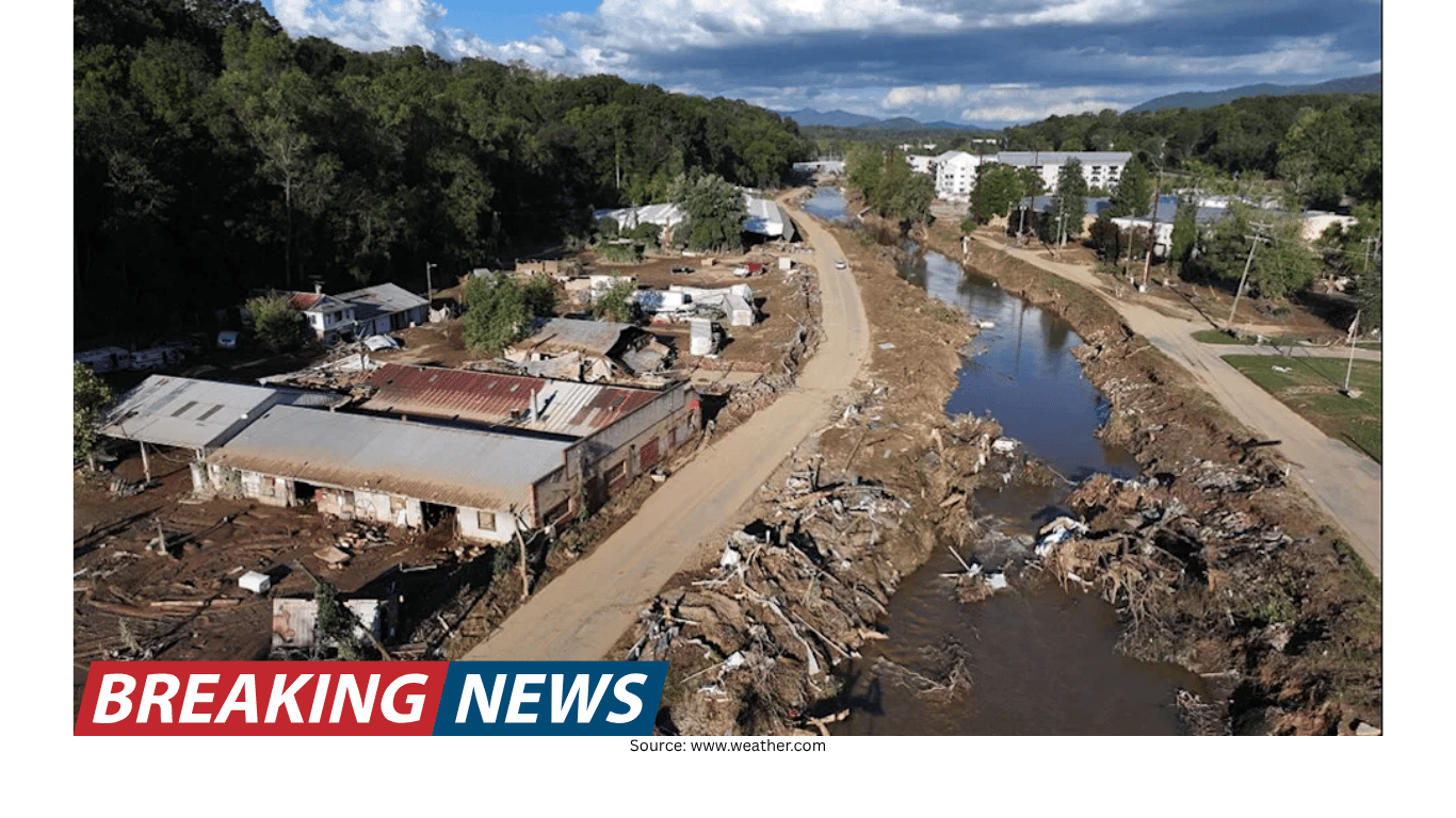
Tonks points to Hurricane Helene as an example of how mountain regions can funnel water into areas that cannot handle that amount of water in such a short period of time. While every event has its own details, the underlying message is consistent: when heavy rainfall interacts with terrain that concentrates runoff, the result can exceed what local channels, roads, and communities are built to manage.
One of the challenges with flash flooding is that it is not solely about how much rain falls at a single point. It is also about where the rain falls relative to drainage paths and how quickly that water is delivered downstream. A community may experience the worst impacts even if the heaviest rain occurred upstream, because the landscape delivers that water into the same corridors people use for travel and daily life.
Flash flood risk is not limited to high mountains
Although mountainous terrain is a notable hotspot, Tonks emphasizes that similar dangers can exist elsewhere. Hilly terrain can also channel runoff quickly, increasing the chance that water will surge into downstream areas with little notice.
Urban areas can face their own version of the problem. When drainage is poor, or when systems are aging or overwhelmed, heavy rain can accumulate rapidly. Streets and underpasses can become temporary channels, and water can build in low spots. The same basic principle applies: when the environment or infrastructure cannot move water away fast enough, flooding can rise quickly.
Another important point is that flash flooding can be a downstream event. Heavy rain upstream can funnel into communities below, meaning people may face hazardous conditions even if the rain where they are standing does not seem extreme. This can contribute to a false sense of security—especially if the sky overhead looks less threatening than the situation developing beyond view.
Detection and communication can be part of the hazard
Flash flooding is dangerous partly because it can outpace awareness. Tonks notes that in some regions, detection and communication can be critical issues. Radar may not be able to accurately measure the amount of rainfall that has already fallen, which can delay warnings.
Even when warnings are issued, getting them to people in time can be difficult in rugged terrain. Limited cell service can reduce the reach of alerts and make it harder for residents and travelers to confirm what is happening nearby. In a fast-evolving flood situation, minutes matter, and any delay in receiving or understanding an alert can narrow the options for safe action.
These challenges can be especially pronounced in mountainous areas, where terrain can interfere with both measurement and communication. But the broader lesson applies elsewhere too: flash flood safety depends not only on weather and geography, but also on how quickly reliable information reaches the people who need it.
When water rises, escape routes can disappear
Another reason flash flooding can be so deadly is that it can remove the very routes people would use to get out. Tonks warns that access to major roadways may already be washed out once flooding begins. During Hurricane Helene, she notes, mountain roadways were washed out and people were left with no way of communicating or traveling to the outside region.
This is a defining feature of flash floods: they can turn transportation corridors into hazards. Roads that follow valleys or run alongside creeks are often the same routes that water will occupy when it surges. Bridges, low-water crossings, and narrow canyon roads can become chokepoints where even a short-lived rise in water can cut off movement.
In that context, waiting to “see how bad it gets” can be a high-risk choice. If a road is passable now, it may not remain passable later. And if communication is limited, people may not know which routes are already compromised.
Why flash flooding is often underestimated
Flash flooding is fast, unpredictable, and frequently underestimated. Part of the underestimation comes from how quickly conditions can change. A creek that looks calm can become dangerous before someone has time to reassess. Another part comes from the way flood impacts can be displaced: the worst water may arrive from upstream, making local conditions feel deceptively normal until the surge arrives.
In mountainous and hilly regions, the combination of funneling terrain and rain-enhancing processes can compress risk into a short period of time. In burn scar areas, reduced absorption can speed the transformation from rainfall to runoff. In cities, drainage limitations can create rapid pooling and hazardous flows. Across these settings, detection limits and communication gaps can further reduce the time people have to react.
Key factors that can make flash flooding hit harder
Funneling terrain: Mountain shapes can concentrate water from a wide area into valleys, turning small creeks into surging torrents quickly.
Orographic lifting: Moist air forced upward by hills or mountains can condense and produce rainfall, adding to the amount of water entering the system.
Burn scars: Post-wildfire soils may absorb water less effectively, increasing runoff and often carrying debris downhill.
Downstream vulnerability: Heavy rain upstream can funnel into downstream communities, creating danger even where local rainfall seems less intense.
Detection and warning challenges: Radar may not accurately measure rainfall that has already fallen, potentially delaying warnings.
Communication and access limits: Limited cell service and washed-out roads can isolate people and reduce options once flooding begins.
Knowing your local risk is part of preparedness
Tonks’ bottom line is that communities should understand what type of weather impacts their region and what makes their location uniquely situated for flash flood impacts. That local context matters. A valley community in mountainous terrain may need to think about how quickly water can be funneled into creeks and roadways. A neighborhood below a burn scar may need to consider how runoff behaves when the soil cannot absorb water quickly. A city area with poor drainage may need to recognize how fast streets can become channels during heavy rain.
Flash flooding does not always provide a long lead time. The more people understand the specific factors that can accelerate flooding where they live or travel—terrain, upstream rainfall pathways, and the realities of communication and road access—the better positioned they are to recognize when conditions are changing and when it is time to move to safety.