Midwest Braces for Another Round of Severe Storms as Weekend Begins
Severe storms return to the Midwest heading into the weekend
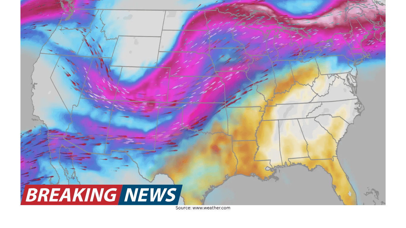
Another bout of severe weather is in the forecast for the Midwest on Friday, continuing a pattern of active conditions as the week turns toward the weekend. The highest concern is centered on Iowa and Missouri, where the potential for tornadoes is specifically highlighted. While storm threats can shift as forecasts are refined, the overall message is clear: parts of the region should be prepared for a potentially dangerous start to the weekend.
The forecast discussion emphasizes that the ingredients for severe storms are expected to come together on Friday. That combination of factors is what can elevate storms from routine thunderstorms into more hazardous events capable of producing tornadoes and other severe impacts. The setup is being closely monitored, and residents in the areas of greatest concern are urged to stay alert for updates and any watches or warnings that may be issued.
Iowa and Missouri in the spotlight for tornado potential
In the latest outlook, Iowa and Missouri are described as being “in the bullseye” for tornadoes. In forecasting terms, that language signals that the environment is expected to be especially favorable for rotating storms in or near those states on Friday. It does not mean that every community will see a tornado, but it does indicate that the risk is higher there than in surrounding areas.
Because tornado risk can be localized and can change quickly, the practical takeaway for people in Iowa and Missouri is to treat Friday as a day requiring extra attention to weather information. Even within a broad risk area, the most intense storms typically develop in narrower corridors. That is why real-time alerts and local updates matter as storms begin to form and move through.
Why forecasters say the “ingredients” are coming together
Meteorologist Rob Shackelford explains that the threat for Friday is tied to the way key storm ingredients are expected to align. Severe weather forecasting often focuses on whether the atmosphere will support strong thunderstorm development and whether storms will be able to organize and intensify. When multiple supportive ingredients overlap in the same place and time, the likelihood of severe storms increases.
The forecast framing for Friday underscores that it is not just a single factor driving the concern. Instead, it is the combination—an atmospheric setup that could help storms develop and become severe as the weekend begins. This is the kind of situation in which storm intensity can ramp up quickly, and where the most impactful weather can occur during a relatively short window once storms initiate.
Timing: a Friday threat that sets the tone for the weekend
The severe weather risk is positioned as a Friday event that “start[s] the weekend,” indicating that the most notable threat is expected as the workweek ends and weekend plans begin. That timing matters for public safety because travel, outdoor gatherings, and evening activities can increase exposure to fast-changing weather. A forecast that highlights the beginning of the weekend is a reminder to factor the potential for storms into scheduling decisions.
For people with Friday afternoon or evening plans, the forecast suggests it may be wise to build flexibility into the day. Severe storms can lead to sudden changes in conditions, including the need to move indoors quickly. Even if storms do not impact every location, being prepared ahead of time is easier than reacting once warnings are issued.
What “severe weather” can mean in practical terms
The forecast specifically points to tornado potential, which is among the most serious hazards associated with severe thunderstorms. While the details of storm mode and exact impacts can vary, the mention of tornadoes signals a need for readiness to respond quickly if warnings are issued. Tornadoes can develop rapidly, and the safest response often depends on having a plan before storms arrive.
In addition to tornadoes, severe storm setups commonly bring other dangerous conditions. The forecast’s emphasis remains on tornado risk in the bullseye area, but the broader severe-weather context is that storms capable of producing tornadoes can also produce other severe impacts. The key point is that Friday’s environment is expected to be supportive of strong storms, which is why forecasters are drawing attention to the setup.
How to use the forecast information without overreacting
Forecasts that highlight a tornado bullseye can understandably raise concern, but it is important to interpret the information in a measured way. A higher-risk area indicates an increased chance of severe storms, not a guarantee of a tornado at any one address. The most useful approach is to treat the forecast as a prompt to prepare and to stay informed as the situation evolves.
That means checking updates as the day approaches, understanding the difference between watches and warnings, and having multiple ways to receive alerts. The forecast discussion’s focus on “ingredients coming together” suggests that confidence is tied to a recognizable pattern, but the exact placement and timing of storms can still shift.
Staying ready: simple steps for Friday in the Midwest
With Iowa and Missouri highlighted and severe storms again expected in the Midwest, a basic readiness checklist can help people respond quickly if conditions worsen. The goal is not to be alarmed, but to reduce the time needed to make decisions if a warning is issued.
Review where you would go if a tornado warning is issued, especially if you are at home, at work, or traveling.
Make sure you can receive weather alerts, including during the overnight hours if storms extend later than expected.
If you have outdoor plans on Friday, identify nearby sturdy shelter options ahead of time.
Check for forecast updates on Friday, since the highest-risk zone can shift as storms develop.
Why repeated severe forecasts matter
The forecast notes that severe weather is “again” expected, implying a recurring pattern rather than a one-off event. Repeated severe weather days can lead to fatigue—people may become less responsive to alerts after multiple rounds of storms. However, each setup is different, and forecasters are emphasizing Friday because the ingredients are expected to align in a way that supports a more serious threat.
That is why the focus on Iowa and Missouri is significant. When forecasters identify a bullseye, it is a signal that the overlap of favorable conditions is expected to be strongest there. Even if earlier storms in the week were less impactful in some locations, Friday’s setup is being treated as one that deserves renewed attention.
What to watch for as Friday unfolds
As the day progresses, the key question will be how storms develop and where the strongest cells track. The forecast framing suggests that the environment will be supportive, but the atmosphere’s final details often determine where the most intense storms form. That is why meteorologists monitor trends throughout the day, including how quickly storms initiate and whether they become organized.
For the public, the most useful approach is to stay aware of changing conditions and to take warnings seriously when issued. The forecast’s emphasis on tornado potential in Iowa and Missouri makes it especially important in those states to have a reliable way to receive urgent alerts and to know what action to take.
Bottom line
Severe weather is forecast to return to the Midwest on Friday, with Iowa and Missouri singled out as the primary focus for tornado potential. Meteorologist Rob Shackelford says the ingredients are coming together in a way that could lead to a more active and potentially dangerous start to the weekend. While the exact storm details will become clearer closer to and during the event, the forecast provides an early signal to prepare, stay informed, and be ready to act quickly if warnings are issued.