A Nation of Contrasts: Snow, Severe Storms, Fire Weather and Flooding Collide in One March Weekend
Mother Nature’s “everything at once” day
Sunday delivered an unusually wide-ranging set of hazards across the United States—an “everything at once” weather day in which multiple high-impact events unfolded simultaneously. While one region dealt with blizzard conditions and record-setting snow, another faced a fast-moving line of severe thunderstorms with tornado watches and warnings. Elsewhere, powerful winds and very dry air elevated wildfire danger across parts of the Plains, and Hawaii endured flooding rain tied to a Kona low and atmospheric river.
This kind of nationwide contrast can be difficult to grasp in real time because the impacts are so different: whiteout travel and road closures in one place, dust storms and fire warnings in another, and flash flooding and power outages thousands of miles away. Yet the common thread was disruption—dangerous travel, widespread power interruptions, and major delays in air travel as storms affected key hubs.
Winter Storm Iona: blizzard conditions and record-setting snow
In the Upper Midwest and Great Lakes, Winter Storm Iona brought heavy snow and gusty winds, producing blizzard conditions in multiple areas. Parts of Wisconsin and Michigan saw heavy, record-setting snow, and the storm’s footprint extended into states including Iowa, Illinois, Michigan, Minnesota, and South Dakota where blizzard warnings were in effect.
Officials in Wisconsin warned residents to stay home as visibility deteriorated and roadways became unsafe. The impacts were severe enough that local authorities issued strict travel guidance. In Minnesota, the Steele County 911 Center escalated its message beyond a suggestion, issuing a no travel alert due to blizzard conditions that dropped visibility to zero. The alert restricted travel to emergencies only, allowing crews to focus on essential rescues.
Nearby, South Dakota took similarly aggressive steps by shutting down hundreds of miles of interstate with no timeline for reopening. Interstate 90 was closed from Sioux Falls to Wall—nearly 300 miles—and Interstate 29 was closed from Sioux Falls to the North Dakota state line.
Snow totals continued to climb through the day. Reports from Minnesota included 17 inches in Millville, with additional snow expected. Farther east and north, forecasts indicated totals could reach 1 to 3 feet, with isolated totals in Michigan’s Upper Peninsula potentially approaching 4 feet. Some two-day snowfall records were at risk of being broken.
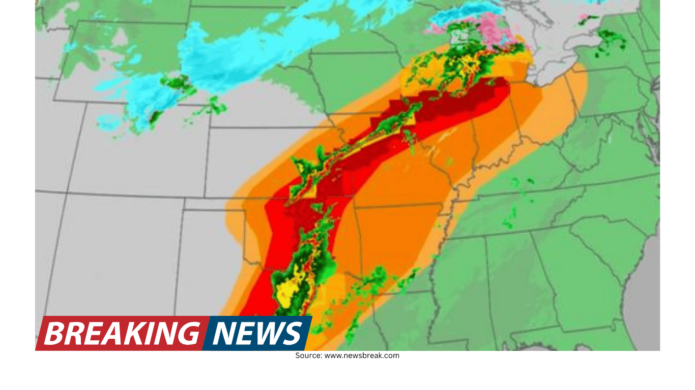
Severe storms and tornado watches from Texas to Illinois
On the southern end of the same storm system, a cold front helped organize a long line of thunderstorms—often referred to as a squall line—stretching from the southern Great Lakes to the Southern Plains. As the line advanced eastward, watches and warnings were issued across a broad swath of the central and southern U.S.
At one point, four tornado watches stretched from northeastern Texas to central Illinois, covering more than 12 million people. Cities included in watch areas included Shreveport, Little Rock, Memphis, and St. Louis. Separate watches were issued for west-central Illinois and parts of Missouri (including St. Louis), for most of Arkansas (including Little Rock) along with parts of Louisiana, Oklahoma, and Texas, and for far east Texas and much of central Louisiana.
Threats cited in the watches included the possibility of tornadoes, damaging straight-line winds with gusts up to 75 mph, and large hail. In one watch, hail up to about 2 inches in diameter was highlighted. The storms were moving quickly, and forecasters emphasized that conditions could deteriorate rapidly for communities in the path of the line.
Warnings also targeted specific metro areas. A tornado warning was issued that included downtown St. Louis as a powerful severe thunderstorm moved into the city. Even without a confirmed tornado at the time, the storm was described as very powerful, underscoring that dangerous wind and hail can occur even when tornado formation is uncertain.
As the evening progressed, the expected severe-weather corridor expanded. The area of enhanced risk was broadened to include a massive region stretching from Indianapolis to the Florida Panhandle, with the potential for intense, widespread, and persistent storms overnight.
Dust storms on the Plains: the danger of a haboob
In parts of Texas, the day’s weather hazards included a dramatic wall of dust—known as a haboob. A haboob is a fast-moving dust storm pushed outward by strong thunderstorm winds. Its most immediate danger is the speed at which visibility can collapse; conditions can go from clear to near-zero in seconds.
That sudden loss of visibility creates a high-risk environment for drivers. One of the most common mistakes in dust storms is continuing to creep forward out of fear of being rear-ended. Experts warn that this behavior can contribute to multi-car pileups when multiple vehicles enter a low-visibility zone and fail to stop safely.
Fire weather and deadly wildfires in Nebraska and nearby states
While some states battled snow and ice, others faced the opposite problem: strong winds mixing with dry air. Across parts of Texas, New Mexico, Oklahoma, and Colorado, Red Flag Warnings were issued, signaling that conditions were favorable for fires to start and spread rapidly. The recipe was straightforward and dangerous—high winds, low humidity, and dry vegetation.
In Nebraska, the threat turned deadly. Governor Jim Pillen confirmed that a woman was killed after being unable to escape the fast-moving Morrill wildfire. Officials said the fire burned nearly 859 square miles, with strong winds and extremely dry conditions aiding its rapid spread and forcing evacuations. A high wind warning remained in effect until 6 p.m. local time.
Fire activity was also noted in Oklahoma, where a new wildfire started near Altus amid strong winds around 50 mph. A Fire Warning was in effect for southwest Oklahoma, and officials urged residents to be ready for possible evacuations and to follow guidance from local authorities.
Hawaii: Kona low, atmospheric river, flooding and damaging winds
Hawaii faced a very different kind of threat as a storm system known as a Kona low set up northwest of the islands. The system brought rounds of heavy rainfall over several days, with flooding impacts and widespread power outages. The storm was also described as an atmospheric river event, and updated, preliminary multi-day rainfall totals were released as the Kona storm continued.
Flood watches remained in place for multiple islands, including the Big Island, Maui, Molokai, Lanai, and Kahoolawe. Flash flood warnings were also in effect across multiple islands as heavy rainfall continued. In addition to torrential rain, the Kona low brought damaging winds and even heavy snow to the state.
Wind impacts were significant. Forecast gusts in lower elevations were expected to reach around 50 mph, while higher elevations could see gusts as high as 100 mph. The combination of saturated ground and strong winds contributed to infrastructure problems, including large-scale power outages.
One striking example of the storm’s force came from Lao Valley, where footage showed a home ripped off the ground as land behind it was swept away due to flooding. The event illustrated how quickly flood conditions can destabilize terrain and structures.
Power disruptions were widespread. At one point, more than 65,000 people were still without power in Hawaii due to the atmospheric river conditions, and separate counts noted more than 40,000 customers without electricity as flooding rains continued.
Power outages and travel disruptions ripple nationwide
With multiple hazards occurring at once, the combined effect on infrastructure was substantial. Nearly 400,000 people across the country were reported without power at one point due to extreme weather. The hardest-hit areas included Indiana, Ohio, and Pennsylvania, where gusty winds ahead of Winter Storm Iona knocked down power lines and contributed to hazardous travel. Michigan and Wisconsin also saw significant outages linked to blizzard conditions.
In Texas and Oklahoma, strong winds knocked out power for more than 60,000 people. The scale of outages across such different weather regimes—snow and ice in one region, wind and fire weather in another, flooding rains in Hawaii—highlighted how multiple types of extreme conditions can strain the grid at the same time.
Air travel also took a major hit. More than 10,000 flights were delayed due to the winter storm, and one of the hardest-hit airports was Hartsfield-Jackson. Travelers reported delays of up to an hour getting through TSA, and long lines were documented as weather, volume, and operational challenges converged.
In a separate tally, more than 1,600 flights were canceled and more than 7,700 delayed across the U.S. as severe weather and high airport volume affected major hubs including Minneapolis, New York, Chicago, Kansas City, and Atlanta. Multiple major airlines suspended or delayed hundreds of flights, leaving travelers stranded or scrambling to rebook. For passengers flying through the Midwest, additional delays and cancellations were anticipated.
Weather whiplash: rapid swings add to the strain
Beyond the headline hazards, the broader pattern included “weather whiplash”—rapid, extreme swings between opposing conditions over a short period. In Denver, a resident noted it took only 13 hours for temperatures to fluctuate between two extremes. In central Wisconsin, a resident highlighted the dramatic change from warm and sunny conditions just days earlier to heavy snow.
Forecasts suggested more whiplash in the days ahead. Cities such as Chicago, Kansas City, and parts of central Virginia were expected to shift back toward colder conditions after a period of warmth.
Meanwhile, the West was dealing with the opposite extreme: hundreds of record highs were expected as temperatures soared 20 to 30 degrees above average. Highs were projected to run well into the 90s and even reach triple digits across the Desert Southwest, pushing conditions closer to mid-summer than early spring.
On the road: what to do before conditions turn dangerous
When winter weather hits, travel can quickly become hazardous, especially when visibility drops and roads close with little notice. Experts recommend keeping a basic emergency kit in your vehicle to reduce risk if you become stranded or delayed by closures.
- Cell phone charger
- First aid kit
- Jumper cables
- Tire chains or snow tires
- Flares
- Water and snacks
- Flashlight
- Full tank of gas
- Bag of sand or cat litter for traction
- Boots, mittens and warm clothes
- Blanket
- Tow rope
- Basic tools such as a shovel, ice scraper and snow brush
In dust storms, the risk can be just as immediate, particularly because visibility can vanish in seconds. The key danger is making decisions while moving in near-zero visibility, which can contribute to chain-reaction crashes.
Understanding “severe weather” and why timing matters
As the squall line pushed east, forecasters updated timing estimates for the South and Ohio Valley, warning that widespread winds as high as 75 mph and tornadoes were possible. These fast-moving lines can compress the window for preparation, especially overnight when people are less likely to receive warnings.
It is also worth noting that meteorologists use the term “severe weather” in a specific way, focusing on thunderstorm impacts rather than using it as a catch-all for any damaging event. During this outbreak, the potential impacts included tornadoes, damaging winds, and large hail—hazards that can occur quickly and vary dramatically from one town to the next.
A single day, many emergencies
From blizzard warnings and interstate closures in the Upper Midwest to tornado watches across the mid-South, from deadly wildfire conditions in Nebraska to flooding rains and damaging winds in Hawaii, the day served as a reminder that the U.S. can experience multiple, simultaneous weather emergencies.
The practical takeaway for the public is less about any single hazard and more about readiness: monitor watches and warnings, take travel restrictions seriously, and plan for disruptions such as power outages and flight delays. On a day when the country’s weather looked like several seasons at once, local conditions—and local guidance—made all the difference.