Oahu Flooding Worsens as Kona Low Brings Repeated Rounds of Heavy Rain
Flooding continues across waterlogged Hawaii
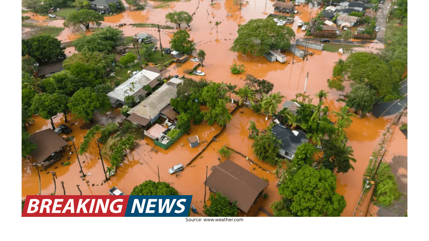
Oahu is facing its worst flooding in more than 20 years as repeated rounds of heavy rainfall continue to soak the island and overwhelm drainage systems. The situation remains fluid, with emergency crews still conducting search-and-rescue operations and officials warning that additional rainfall could prolong or worsen impacts in already inundated areas.
More than 230 people have been rescued so far, underscoring both the scale of the flooding and the rapid rise of water in some communities. In addition, around 5,500 people remain under evacuation orders, driven in part by concerns about rising water levels at the Wahiawa dam. Officials have emphasized urgency in evacuation messaging, warning residents to leave immediately in some areas.
Damage estimates rise as assessments remain incomplete
Officials say the destruction is widespread, affecting homes and key infrastructure. Damage estimates have already reached $1 billion and are still climbing. The impacts described include damage to homes, roads, schools, airports, and a hospital on Maui.
Even with the scale of damage becoming clearer, local leaders have cautioned that full assessments are not yet possible in many places. Honolulu Mayor Rick Blangiardi said that dozens—if not hundreds—of homes were damaged, but officials have not been able to fully assess the destruction. Floodwaters, debris, and ongoing rainfall can slow inspections and complicate efforts to document losses, meaning initial estimates may change as access improves.
Rescues continue, including an airlift from a youth camp
Emergency response has remained active as conditions evolve. Search-and-rescue operations are ongoing, and responders have carried out large-scale evacuations in areas cut off by floodwaters.
In one major operation, the National Guard and the Honolulu Fire Department airlifted 72 children and adults who had been attending a spring break youth camp in affected areas. The airlift highlights the challenges posed by flooded roads and the need to use aircraft when ground access becomes unsafe or impossible.
Health impacts have also been reported. At least 10 people have been hospitalized for hypothermia, a reminder that flooding events can bring dangerous exposure risks even in places often associated with warm weather. Prolonged contact with water, wind, and rain can lower body temperature, particularly for people who are stranded or forced to evacuate in difficult conditions.
Wahiawa dam under close watch amid warnings of potential failure
A central concern in the ongoing emergency is the 120-year-old Wahiawa dam, which officials say is near critical levels and at risk of failing. Rising water levels have contributed to continued evacuation orders, and officials have issued stark warnings to residents in nearby areas.
Authorities have told residents to leave immediately, warning that the dam “may collapse or breach at any time.” The warning also advised residents to carpool due to heavy traffic on the island, signaling both the urgency of evacuation and the logistical challenges of moving large numbers of people quickly.
Even as rain slows at times, officials remain concerned about runoff from repeated rainfall. The cumulative effect of multiple rounds of rain can keep streams high, saturate soils, and maintain pressure on waterways and flood-control structures. In this case, officials have expressed concern that the dam could be overtopped, which can occur when water levels rise beyond the structure’s capacity to safely contain or release water.
North Shore inundation prompts sirens and “LEAVE NOW” orders
Some of the most urgent warnings have been issued for areas on Oahu’s North Shore. Emergency sirens blared along the North Shore as rising waters damaged homes and flooding conditions intensified.
Honolulu officials issued a “LEAVE NOW” evacuation order at 5:35 a.m. Friday for Waialua and Haleiwa. The alert cited “Extremely dangerous flooding and Wahiawa Dam is high,” reflecting the dual threats of immediate floodwaters and the broader risk tied to dam conditions.
The North Shore of Oahu has been under flash flood warnings since early Friday morning. Flash flooding can develop quickly, especially when intense rainfall falls on already saturated ground or drains into steep terrain and narrow channels. In such conditions, water can rise rapidly with little time for residents to react, making early warnings and swift evacuations critical.
What’s driving the flooding: a Kona low and repeated moisture surges
This round of flooding rain is being caused by a Kona low located north of Hawaii. However, officials and forecasters note that the current danger is also tied to the aftermath of earlier heavy rain. Repeated rounds of rain and resulting runoff since last week’s heavy rainfall have continued to escalate flood concerns.
Kona lows are low-pressure systems known for reversing winds across the Hawaiian Islands. That reversal can direct moisture and storms into communities that do not typically experience such foul weather, bringing heavy rainfall and gusty winds. In other words, the same locations that may be accustomed to more stable conditions can find themselves dealing with intense rain and wind when the pattern shifts.
Forecasters described a series of low-pressure systems that continue to draw tropical Pacific moisture and push it over the Hawaiian Islands. With very heavy rainfall in the first of these Kona lows last weekend, followed by additional systems, the rainfall totals have “really added up.” Without an extended break, flooding could continue for a while, especially as runoff keeps waterways elevated and ground conditions remain saturated.
Rainfall totals and the outlook for the coming days
Parts of Oahu have already recorded 8 to 12 inches of rain. Several additional inches are expected over the weekend, according to the forecast information provided. With soils already saturated and waterways running high, even moderate additional rainfall can lead to renewed flooding, particularly in low-lying areas and along streams.
Most of the state remains under a flood watch, indicating continued potential for flooding conditions beyond the hardest-hit locations. Flood watches are typically used when conditions are favorable for flooding, and they can be upgraded to warnings when flooding is imminent or already occurring.
How the broader weather pattern may be influencing Hawaii’s conditions
Senior digital meteorologist Jonathan Belles described the flooding as connected “in some ways” to a broader pattern affecting other parts of the United States. He noted that when one area experiences heat, another can experience cooler, wetter weather, describing a larger-scale setup that can persist across regions.
Belles said that the West is seeing heat and the East is seeing slightly stormier weather, and that the pattern “continues west, too,” with cooler, wetter weather persisting over Hawaii and into Alaska. He added that until a major storm system shifts the pattern or it slowly breaks down, “this flooding and heat will persist.” The takeaway for residents is that the current conditions may not be a brief, isolated event, particularly if the pattern continues to support repeated moisture surges and additional rain.
State response: National Guard activation and ongoing emergency operations
The Hawaii National Guard has been activated in response to the flooding, supporting operations as conditions remain dangerous in multiple areas. The activation comes as rescues continue and evacuations remain in place for thousands of residents.
Gov. Josh Green described the storm as “very severe right now,” particularly on the northern part of Oahu. He added that “it’s going to be a very touch-and-go day,” reflecting the uncertainty that can accompany major flooding events, where conditions can change quickly with additional rain, shifting runoff, and infrastructure stress.
Key facts at a glance
- Oahu is experiencing its worst flooding in more than 20 years.
- More than 230 people have been rescued so far.
- About 5,500 people remain under evacuation orders, partly due to concerns at the Wahiawa dam.
- Damage estimates have reached $1 billion and are rising, with impacts to homes and infrastructure including roads, schools, airports, and a Maui hospital.
- The National Guard and Honolulu Fire Department airlifted 72 children and adults from a spring break youth camp.
- At least 10 people have been hospitalized for hypothermia.
- Parts of Oahu have seen 8–12 inches of rain, with several more inches expected over the weekend.
- The 120-year-old Wahiawa dam is near critical levels; officials warned it may collapse or breach at any time.
- Most of the state remains under a flood watch.
What residents are being told right now
Officials have issued clear evacuation guidance in the hardest-hit areas, including “LEAVE NOW” orders for Waialua and Haleiwa during the height of the emergency. For residents near the Wahiawa dam, authorities have warned that the structure may fail and have urged immediate evacuation, including advice to carpool because of heavy traffic.
With flash flood warnings in effect earlier for the North Shore and flood watches covering much of the state, the overarching message from officials is that flooding remains dangerous and dynamic. Continued rainfall, runoff from earlier storms, and ongoing concerns about critical infrastructure mean residents should remain prepared for changing conditions.
Portions of the report information were attributed to the Associated Press in the provided material.