April Monthly Outlook: Warmer Signals Expand, While the Northeast Stays Cooler
April’s updated outlook: warmer in many regions, but not everywhere
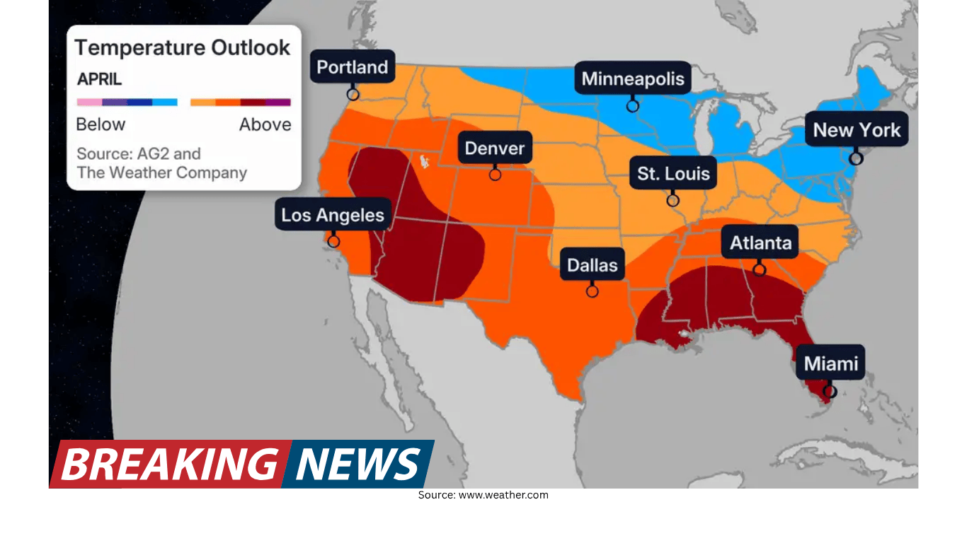
The latest April monthly outlook indicates that much of the United States is trending warmer than previously expected. The update points to above-average temperatures across a wide corridor that stretches from the Pacific Northwest down through the Southwest, then eastward through the Central U.S. and into the Southeast. At the same time, the outlook is not uniformly warm: the Northeast stands out again as the main region expected to run below average for the month.
Alongside the temperature forecast, the precipitation outlook continues to emphasize wetter-than-average conditions across a large portion of the Central U.S. That wet signal has also been adjusted in the newest update, with the wetter-than-average area in the Central Plains slightly expanded.
While monthly outlooks are broad by design, this update is notable because it includes “quite a lot of changes” compared with the previous forecast. Several regions saw meaningful shifts in the temperature pattern, and the updated precipitation outlook helps explain why some areas may not warm as much as nearby regions despite a generally warmer national picture.
Where above-average temperatures are favored
The updated temperature outlook favors above-average readings across a large portion of the country. The areas highlighted for warmth include:
- The Pacific Northwest
- The Southwest
- Much of the Central U.S.
- The Southeast
This broad warm zone is one of the defining features of the April update. Rather than being confined to a single region, the above-average signal spans multiple climate zones and extends across a long west-to-east swath.
However, the map is not a blanket forecast of warmth for every location. The outlook emphasizes that not everyone will experience warmer-than-average temperatures, and the Northeast remains the clearest exception.
The Northeast: the primary cool spot again
The only below-average area highlighted in the updated outlook is the Northeast. This means that, while much of the rest of the country is leaning warmer than average, the Northeast is expected to be cooler than the seasonal norm for April.
The outlook also notes a refinement in the cool pattern: while the bulk of the Midwest and the Northeast are still expected to be slightly below average, there has been a “slight trimming back” of that cooler zone. In practical terms, that suggests the below-average area is not as extensive as it was in the prior forecast, with slightly warmer-than-average conditions expected farther north than before.
Even with that adjustment, the overall message remains consistent: the Northeast is still the key region where cooler-than-average conditions are favored in April.
Biggest changes from the previous forecast
Forecast updates are routine, but this April outlook stands out because of the magnitude of the changes described. Two regions are singled out as especially important to watch: the Southeast and the Pacific Northwest.
Southeast upgrade: from slightly warm to well above average
One of the most prominent changes is in the Southeast. In the updated outlook, the Southeast has been “upgraded” to call for well above-average temperatures. Previously, the region was mainly projected to be only slightly above average or generally warmer than normal.
This shift matters because it changes the character of the forecast. A slight warm tilt can mean occasional warm spells mixed with cooler interruptions, while a well-above-average signal implies a stronger and more persistent tendency toward warmth through the month.
Pacific Northwest and Northern Plains: a notable warm shift
Another substantial change involves the Pacific Northwest and the Northern Plains. The update describes a “rather drastic shift” in this region. In the previous outlook, there had been a more clearly defined below-average area across parts of the region. In the newest update, that cooler shading is “gone now,” replaced by a warmer signal.
This is a meaningful reversal. Instead of leaning cooler than average, the Pacific Northwest and Northern Plains are now included in the broader above-average temperature zone that extends across the western and central parts of the country.
Midwest and Northeast: cool signal remains, but slightly reduced
While the Midwest and Northeast still lean slightly below average overall, the updated forecast trims back the extent of that cooler area. The change is described as a slight reduction, with slightly warmer-than-average temperatures expected farther north than in the previous outlook.
This kind of adjustment can be important for interpreting the map: it suggests the dividing line between cooler and warmer-than-average conditions has shifted. Even small changes in that boundary can alter which communities are more likely to fall on the cool side versus the warm side during the month.
Precipitation outlook: wetter conditions expand in the Central Plains
On the precipitation side, the updated outlook continues to favor wetter-than-average conditions for much of the Central U.S. The update specifically notes that the wetter-than-average forecast for the Central Plains has been “slightly expanded.”
This is a key detail because precipitation can influence how temperatures average out over a month. Frequent storm systems and increased cloud cover can suppress daytime highs, while rainfall can also affect local conditions by limiting how quickly the ground warms.
The outlook points to a small area of above-average temperatures within the Central U.S. and explains that this feature is connected to the precipitation pattern. In this case, increased precipitation is described as keeping average temperatures “down a bit.” In other words, even within a generally warm national outlook, wetter conditions can temper the degree of warming in some places.
Why the pattern looks this way: two main factors
The update highlights two primary factors that help explain the temperature map: the jet stream pattern affecting the Northeast and the behavior of the polar vortex. Together, these features help account for why the Northeast stays cooler while warmth is more widespread elsewhere.
Jet stream setup: storm track keeps the Northeast cooler
The Northeast’s cooler outlook is linked to the jet stream. The update describes a “slow track to the north of the jet stream,” which is considered typical for this time of year. This configuration can steer more storm systems into the Northeast.
More frequent storms can keep temperatures lower by increasing cloud cover and reinforcing cooler air masses. In the context of a monthly outlook, the key point is that a stormier pattern can prevent sustained warmth from taking hold, resulting in below-average monthly temperatures even as other regions trend warmer.
The polar vortex: when it weakens, cooler air can plunge south
The second major factor discussed is the polar vortex, described as a low-pressure system spinning at the North Pole. The update explains that when this low-pressure system is strong, cooler air tends to remain “stuck at the poles.” When it weakens, it can allow cooler temperatures to push south, particularly along the Northeast.
This same pattern can also support warmth in the West. The update notes that the setup which allows cooler air to plunge south into the Northeast “also helps make it warmer in the West.” This relationship helps explain why the outlook can simultaneously feature a cooler Northeast and a warmer West.
La Niña fades, El Niño emerges: a backdrop for the months ahead
Beyond the immediate April pattern, the update places the forecast in a broader seasonal context. It states that the La Niña that was ongoing during the winter has largely subsided and that an El Niño is on the way. The El Niño is expected to be strong, and the update notes that this shift can lead to “interesting conditions” and may contribute to temperature outcomes over the coming months.
While the April outlook focuses on near-term conditions, the mention of a developing El Niño provides context for how the larger climate pattern could influence temperature tendencies as the seasons progress.
What the outlook suggests for summer heat risk
The update also includes guidance about potential implications later in the warm season. It warns that the emergence of a strong El Niño over the next few months “should limit the risks for big heat across the eastern US this summer,” with the most anomalous heat extending from Texas northwestward to the Pacific Northwest.
This is not a day-to-day forecast, but a broad statement about where the strongest departures from average heat might be most likely if the expected pattern develops. It also aligns with the April map’s theme of widespread warmth across the West and central parts of the country, while the East—particularly the Northeast—does not share the same degree of warmth in the near term.
How to read a monthly outlook
Monthly outlooks describe the likelihood of conditions being above or below average over a long period rather than predicting the weather on any specific day. A region marked as above average can still experience cooler stretches, and a region marked as below average can still see warm days. The value of the outlook is in identifying the prevailing tendency for the month.
This updated April outlook underscores that point. The country can lean warmer overall while still maintaining a distinct cool pocket in the Northeast. Similarly, the precipitation outlook shows how wetter conditions in parts of the Central U.S. can influence temperature outcomes by keeping averages from rising as much as they might otherwise.
Key takeaways from the updated April forecast
- Warmer-than-average conditions are favored across a large area from the Pacific Northwest to the Southwest, through the Central U.S., and into the Southeast.
- The Northeast is the primary region expected to be below average in temperature again this month.
- The Southeast has been upgraded to a forecast of well above-average temperatures.
- The Pacific Northwest and Northern Plains shifted notably warmer, with a previously cooler zone removed in the latest update.
- The Midwest and Northeast remain slightly below average overall, but the cool area has been trimmed back somewhat.
- Wetter-than-average conditions are expected across much of the Central U.S., with the wetter area in the Central Plains slightly expanded.
- Jet stream placement and polar vortex behavior are highlighted as major drivers of the cooler Northeast and warmer West pattern.
- La Niña has largely subsided, and a strong El Niño is expected, which may influence conditions in the coming months and could limit extreme heat risk in the eastern U.S. this summer.
As April progresses, the updated outlook provides a roadmap for the month’s dominant themes: broad warmth across many regions, a persistent cooler signal in the Northeast, and an active precipitation pattern across the Central U.S. that can shape how temperatures average out.