Florida Braces for Rounds of Rain: Drought Relief Arrives With a Flooding Caveat
A week of needed rainfall, with a catch
After an extended stretch of dryness, Florida is expected to see a more active stretch of weather this week, with rounds of rain and storms forecast to cross the state. For many communities, the incoming rainfall is welcome news: parts of Florida have been dealing with drought conditions described as among the worst the state has experienced this century. But the same pattern that can deliver relief can also create problems if the rain arrives too fast, too intensely, or repeatedly over the same locations.
Forecasters expect multiple waves of moisture to move through the Florida Peninsula, bringing widespread rainfall totals that could exceed several inches in some areas. The overall setup is expected to bring a meaningful change from the recent lack of precipitation. At the same time, millions of residents could face a flooding threat if heavy downpours develop, particularly in urban areas where water has fewer places to go and drainage can be overwhelmed.
The key message for this week is balance: Florida needs rain, but drought-stricken ground often struggles to absorb rapid, intense rainfall. In that scenario, water can run off instead of soaking in, limiting drought benefits and increasing the risk of flooding.
What’s driving the rain: a stalled front and an upper-level boost
The first round of rain is expected to move through into Tuesday as a cold front stalls over the state. A stalled front can act as a persistent boundary, helping to focus clouds and precipitation over the same general region. This initial wave is expected to be enhanced by an upper-level disturbance, a feature in the atmosphere that can increase lift and help showers and storms become more widespread or more efficient rain producers.
With the front lingering and upper-level support in place, rainfall is expected across much of the Florida Peninsula early in the week. This is the first phase of a multi-part pattern, rather than a one-and-done event.
A brief midweek pause, then another surge
After the early-week rainfall, Wednesday is expected to bring a slight lull—an interval that may allow some areas to drain and recover before the next wave arrives. But the break is not expected to last long. Another surge of moisture is forecast to arrive Thursday, renewing the chance for showers and storms.
The timing matters for both daily routines and planning: with a lull in the middle of the week and most of the rain expected to wrap up by Friday, the overall pattern suggests that weekend plans should not be impacted by this particular round of wet weather.
Where the heaviest rain is expected
Not every part of Florida is expected to see the same rainfall totals. The heaviest rain is forecast to focus along the eastern coastline of Florida through Friday. Widespread totals of more than 3 inches are expected in that corridor. In addition, isolated totals above 5 inches are possible if storms become slow-moving or repeatedly track over the same areas.
That caveat—storm speed and repetition—is crucial. Even in a week when the state needs rain, localized downpours can create sharp differences from one neighborhood to the next. A slow-moving storm can drop a large amount of rain in a short time, while nearby areas may see far less.
Among the locations mentioned as needing to stay alert are Daytona Beach and Melbourne, both situated along the east coast where the heaviest rainfall is expected to concentrate. Residents in these areas should pay particular attention to how storms evolve, especially if rainfall becomes persistent or intense.
Rainfall totals by region
Forecast totals vary across the state, with the highest amounts expected along the east coast and lower totals elsewhere. Across the southern portion of Florida, including Miami, totals of 1 to 3 inches are expected. Farther north, including Jacksonville, and westward into the Florida Panhandle, including Tallahassee, totals could be around an inch.
Even an inch can be meaningful in a dry period, but the distribution matters. Areas that have missed out on rain for weeks or months often need repeated, steady events to make a noticeable dent in drought conditions. Meanwhile, places that receive several inches in a short window may face immediate flooding concerns even if the longer-term drought picture improves only modestly.
East coast (through Friday): Widespread totals over 3 inches; isolated totals over 5 inches possible with slow-moving storms. Daytona Beach and Melbourne are among the cities urged to stay alert.
South Florida (including Miami): About 1–3 inches expected.
North Florida and Panhandle (including Jacksonville and Tallahassee): Around an inch possible.
Why drought relief can still come with flooding
It may seem counterintuitive that a drought-stricken region could face flooding, but the relationship between dry ground and heavy rain is well established. When soil has been dry for an extended period, it often becomes less able to absorb water quickly. Instead of soaking in, rainfall can run off the surface, especially when downpours are intense or prolonged.
Forecasters caution that some places could see rapid rainfall rates this week. When rain falls that quickly, the soil may not have enough time to take it in. The result can be localized flooding, particularly in urban areas where pavement and other hard surfaces further reduce absorption. In those settings, water can accumulate rapidly, and drainage systems may struggle if rainfall rates are high.
This is why the pace of rainfall matters nearly as much as the total. Steady, moderate rain is generally more effective at chipping away at drought conditions because it can infiltrate the soil. Fast, heavy rain can produce runoff and flooding, offering less benefit to the ground moisture that drought relief depends on.
Florida’s drought backdrop: an unusually dry year so far
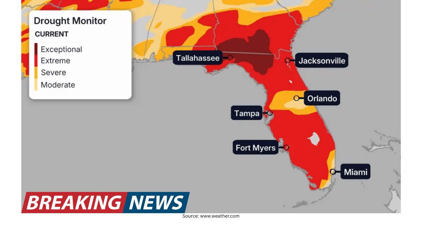
The incoming rain arrives against a stark backdrop. Florida is described as being in one of its worst droughts this century. According to the U.S. Drought Monitor, the state is in the highest category of extreme drought (D3) at a level not seen in more than 25 years. The only periods noted as having a higher amount of exceptional drought (D4) were January 2000 and December 2011.
Rainfall deficits help illustrate what that means on the ground. Tallahassee, for example, has received only 6.50 inches of rainfall so far this year. For comparison, the average year-to-date rainfall for this time of year is nearly 15 inches—more than double Tallahassee’s current total. Other cities including Jacksonville, Orlando, and Daytona Beach are also running well below normal.
Those numbers underscore why this week’s rain is so closely watched. In drought conditions, a single wet week can help, but the broader recovery often depends on repeated episodes of soaking rain over time.
What to watch for as storms move through
Because the forecast includes the potential for heavy, slow-moving storms, the most important details may come down to timing and storm behavior. A widespread expectation of several inches along the east coast does not mean every location will see the same outcome. Some communities could see manageable rainfall spread over many hours, while others might experience intense bursts that overwhelm local drainage.
Several factors described in the forecast are worth monitoring as the week unfolds:
Storm speed: Slow-moving storms increase the chance of high totals in a small area.
Repeated storm tracks: If storms move over the same locations multiple times, totals can climb quickly.
Rainfall rate: Rapid rates can outpace the soil’s ability to absorb water, increasing runoff.
Urban vulnerability: Cities and built-up areas are more prone to flooding when heavy rain falls in a short time.
Planning around the forecast: midweek variability, weekend improvement
For residents and visitors trying to plan the week, the forecast suggests a pattern with some variability. The first round of rain extends into Tuesday, followed by a slight lull on Wednesday. Another moisture surge is anticipated Thursday, with most of the rain expected to wrap up by Friday. That sequence points to a wet stretch during the workweek, followed by improved conditions for the weekend.
Even with that general timeline, day-to-day impacts can differ depending on where storms concentrate. Along the east coast, where the heaviest rain is expected, the chance of disruptions from downpours is higher through Friday. Elsewhere, lower totals may still bring beneficial rain without the same level of flooding concern, though localized heavy showers can still occur.
The bottom line: beneficial rain, but not all rain is equal
Florida’s forecast for this week highlights a familiar tension in weather: the same event can be both helpful and hazardous. Many areas need rainfall badly, and rounds of showers and storms are expected to deliver that relief. Yet the forecast also warns that some places could receive too much rain too quickly, especially along the eastern coastline where totals could exceed 3 inches and isolated pockets could top 5 inches if storms slow down or repeat.
With drought-stricken soil less able to handle rapid rainfall, flooding should not be ruled out—particularly in urban areas. The most favorable outcome would be widespread rainfall delivered at rates that allow the ground to absorb it, helping to chip away at drought conditions rather than sending water rushing into streets and storm drains.
As the week progresses, the evolving details—where storms stall, how quickly they move, and how intense the rainfall becomes—will determine whether the rain is primarily a drought-soothing event, a flooding headache, or, in some places, a bit of both.