A Messy Late-Winter Pattern Sets Up Across the Northern U.S. This Week
Winter lingers in the North as the South turns warmer
While many communities across the southern United States are enjoying warmer temperatures, winter is not finished with the northern tier. The overall setup this week points to a split in conditions: milder air holding over parts of the South, and a more wintry pattern persisting across northern portions of the country.
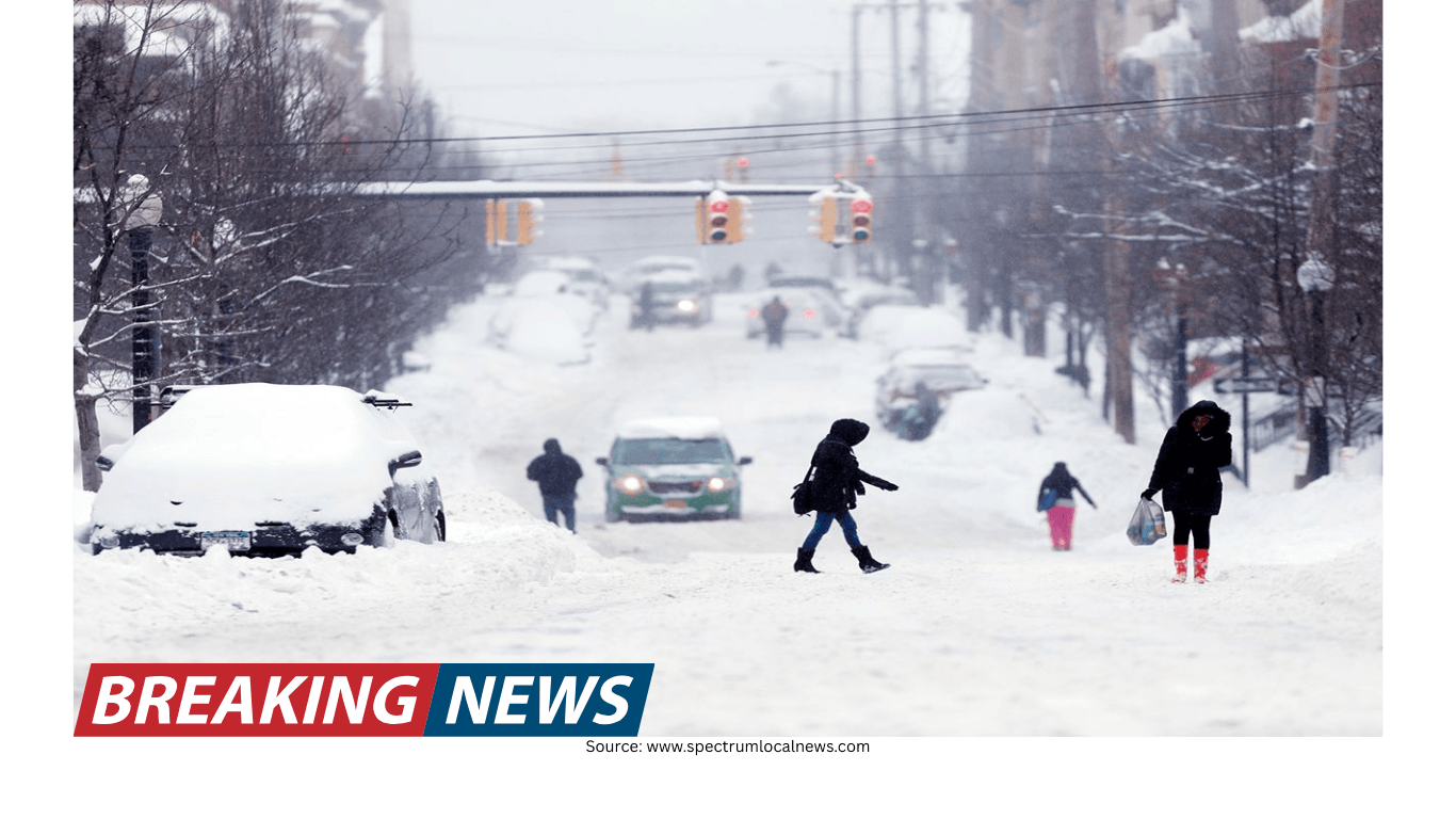
For travelers, commuters, and anyone with plans that depend on road conditions, the key message is that the week may be less about major snow totals and more about the kind of “messy” mix that can create localized problems. Light snow is in the forecast for a broad zone, and the chance of ice is also in play—an important detail because even small amounts of ice can quickly change how safe roads and sidewalks are.
Where light snow and ice are possible today
The immediate focus is on a corridor stretching from the Ohio Valley to the Appalachians, with wintry weather also possible in parts of the mid-Atlantic. In these areas, light snow is expected, and there is also the potential for ice. This combination is often what makes a forecast feel complicated on the ground: precipitation may not be heavy, but it can still create slick conditions, especially during the parts of the day when people are most likely to be on the move.
Because the setup includes both snow and the chance of ice, conditions can vary from one town to the next. Some places may see mainly light snow, while others may contend with more of a glaze or mixed precipitation. The practical takeaway is that impacts may be uneven, and that the most disruptive spots may not always be the ones that typically see the most snow.
Why this kind of forecast can be tough on commutes
Light snow and ice are often underestimated hazards, particularly when temperatures are hovering near freezing. Even if snowfall rates are not intense, a thin layer of snow can reduce traction and visibility. Add the possibility of ice, and the risk increases: ice can form a slick surface that is difficult to see, turning bridges, overpasses, and untreated roads into trouble spots.
In the Ohio Valley, the Appalachians, and parts of the mid-Atlantic, today’s wintry mix could mean problems for commutes. The concern is not limited to long-distance travel; short trips can become more challenging when roads are patchy and conditions change quickly over a small area.
For those who must drive, the main issue is that the worst conditions may coincide with the busiest travel times. Even a modest weather event can ripple outward into slower traffic, longer travel times, and an increased likelihood of minor accidents. Pedestrians may also notice more slippery sidewalks and steps, particularly where ice develops.
What to expect later this week in the Northeast and New England
The pattern does not end with today’s wintry weather. As the week continues, additional snow and some ice are expected for portions of the Northeast and New England. This suggests a continuation of winter’s grip in the region, with multiple opportunities for slick travel rather than a single, brief event.
Not every location in the Northeast and New England will necessarily see the same outcome, but the overall theme is that wintry precipitation remains in play. The mention of “some ice” is particularly notable, as it indicates that at least part of the region could see conditions that are more disruptive than a straightforward snowfall.
For residents, this may mean staying alert for changing forecasts throughout the week. For travelers, it may mean building extra time into plans and being ready for delays if snow or ice spreads into your specific area.
Understanding the term “messy winter setup”
When forecasters describe a “messy” winter setup, they are often pointing to a situation where precipitation type and impacts can be difficult to pin down far in advance. The phrase can also reflect the reality that a storm does not need to be extreme to cause headaches. A little snow here, a touch of ice there, and a shifting line between the two can create a patchwork of conditions that is hard to summarize with a single number or headline.
In this week’s case, the messy aspect comes from the combination of light snow and the chance of ice across a wide swath—from the Ohio Valley to the Appalachians and into parts of the mid-Atlantic—followed by additional wintry weather in portions of the Northeast and New England. That broad footprint increases the odds that many people will encounter at least some winter impacts, even if the severity varies.
Practical considerations for drivers and commuters
Because the forecast emphasizes light snow and possible ice, the most useful preparation is often practical rather than dramatic. The goal is to reduce exposure to the most hazardous moments—when roads first turn slick, when traffic is densest, and when conditions are changing.
Plan for slower travel: If you are in the Ohio Valley, Appalachians, or parts of the mid-Atlantic, allow extra time today in case light snow or ice affects the commute.
Expect variability: Conditions can differ across short distances when snow and ice are both possible, so a route that looks fine at one point may worsen quickly elsewhere.
Stay flexible later in the week: Portions of the Northeast and New England may see additional snow and some ice, which can complicate midweek and late-week travel plans.
Even when accumulation is not the main story, the presence of ice can be a decisive factor in how disruptive the day becomes. A light event can still lead to significant slowdowns if roads become slick at the wrong time.
What this means for day-to-day life across the affected regions
For many people, the most immediate effect of a late-winter pattern is not the snowfall itself but the way it changes routine. School drop-offs, work commutes, appointments, and deliveries can all be affected when roads are less reliable. In areas where ice is possible, even a brief period of freezing conditions can create hazards that linger longer than the precipitation.
In the Ohio Valley through the Appalachians and into parts of the mid-Atlantic, today’s light snow and potential ice may create a stop-and-go feel to the day, especially if conditions deteriorate during peak travel hours. Farther northeast, the expectation of additional snow and some ice later this week suggests that winter impacts may come in more than one round.
It is also worth noting the contrast highlighted in the broader national picture: while the South enjoys warmer temperatures, the North continues to deal with winter’s leftovers. That split can influence travel between regions, as someone leaving a mild location may arrive in a place where roads and sidewalks are wintry.
How to follow the latest forecast for your area
Because this week’s pattern involves multiple regions and a mix of precipitation types, the most reliable approach is to check the latest forecast specifically for your location. The overall setup provides a roadmap—light snow and possible ice from the Ohio Valley to the Appalachians and parts of the mid-Atlantic today, then additional snow and some ice for portions of the Northeast and New England later in the week—but the details that matter most are local.
Small changes in timing can make a big difference in how a commute feels. Likewise, small differences in temperature can influence whether precipitation falls as snow or contributes to icing. Staying updated can help you make better decisions about when to travel, which routes to take, and how much extra time to allow.
Key takeaways for the week ahead
The South is warmer, but winter persists in the North: Northern portions of the U.S. remain in a wintry pattern even as warmer temperatures spread across much of the southern U.S.
Today’s focus includes the Ohio Valley, Appalachians, and parts of the mid-Atlantic: Light snow and the chance of ice could create travel issues, particularly for commutes.
More wintry weather is expected later in the week in the Northeast and New England: Additional snow and some ice are possible for portions of those regions.
Impacts may be uneven: A “messy” setup can produce patchy conditions, where some areas see minor issues and others face more significant slick spots.
Winter may be easing in some parts of the country, but this week is a reminder that northern regions can still see disruptive weather even when snowfall is described as “light.” With ice also in the forecast for some locations, the safest approach is to treat the week as a period of heightened travel awareness—especially during commutes—and to keep an eye on the latest local updates as conditions evolve.