How a Quieter Hurricane Season Could Shape Drought Risk in the South and Southeast
El Niño, hurricane activity, and why rainfall matters
A strong El Niño is forecast to develop in the coming months, and that matters for more than just ocean temperatures and global weather patterns. In the Atlantic, El Niño is commonly linked with a lower number of hurricanes. A quieter season can sound like unambiguous good news—fewer storms making landfall generally means fewer direct hits, fewer evacuations, and less damage.
But in the South and Southeast, the relationship between tropical activity and water supply is complicated. Tropical storms and hurricanes are dangerous, and no one wants to see them make landfall. At the same time, these systems can deliver widespread rainfall that becomes part of a region’s annual precipitation totals. When drought is expanding, the absence of that rainfall source can become a concern.
In other words, a season with fewer tropical systems can reduce one kind of risk while increasing another: the risk that already-dry soils and stressed water resources stay dry through the hottest part of the year.
How much rain can tropical systems contribute?
Tropical systems account for a meaningful share of seasonal precipitation across the southern region of the United States. In some places, the contribution is large enough that a change in storm frequency—or a change in storm tracks—can show up in rainfall totals.
Across the southern region, tropical systems can contribute anywhere from about 10% to nearly 30% of seasonal precipitation. The highest percentages are found in Florida, Louisiana, and North Carolina, where tropical systems can make up roughly 20% to 30% of seasonal precipitation. These figures come with an important caveat: each storm is different, and each season can vary widely. A single landfalling storm can dramatically shift local rainfall totals, while a season with storms that stay offshore may do little for drought.
That variability is part of what makes drought planning difficult. A region can go months with little rain, then receive a short period of intense rainfall that eases drought in one place but causes flooding in another. The balance between “helpful rain” and “harmful flooding” is often determined by storm intensity, speed, and where the heaviest bands set up.
The “best-case” rain scenario—and why it’s hard to get
When it comes to drought relief, the most favorable tropical setup is not a major hurricane. A best-case scenario is often described as a tropical storm or weak hurricane that moves at a moderate pace—slow enough to drop a useful amount of rain, but not so slow or intense that it produces widespread damage and catastrophic flooding.
In that ideal case, rainfall arrives in a “reasonable amount” over a “reasonable amount of time,” boosting seasonal totals without severely disrupting daily life. It is a narrow target, and it’s not something forecasters can count on. Still, it explains why a reduction in tropical activity can raise concern in drought years: fewer systems means fewer chances at that beneficial, drought-easing rainfall.
The idea has a parallel in the western United States, where residents often hope for atmospheric rivers that bring needed moisture. Just as those events can be both beneficial and hazardous, tropical systems can be both a source of water and a source of danger.
Drought has expanded sharply across the Southeast and South
Across the Southern Tier of the United States, conditions have become notably dry. The ground is described as parched in many areas, and drought coverage has expanded compared with the same time last year.
Nearly 75% of the Southeast is experiencing “severe drought,” a striking increase from just 3% a year ago. In the South, 86% of the region is in drought conditions, up from roughly 35% a year ago. Those figures highlight how quickly drought can intensify and spread—especially when rainfall is inconsistent and temperatures rise into summer.
When drought coverage reaches that scale, the question becomes not only whether rain will arrive, but also when. Timing matters because summer heat increases evaporation and plant water demand, which can worsen soil moisture deficits. Rain that arrives early can help stabilize conditions; rain that arrives late may not prevent impacts from building.
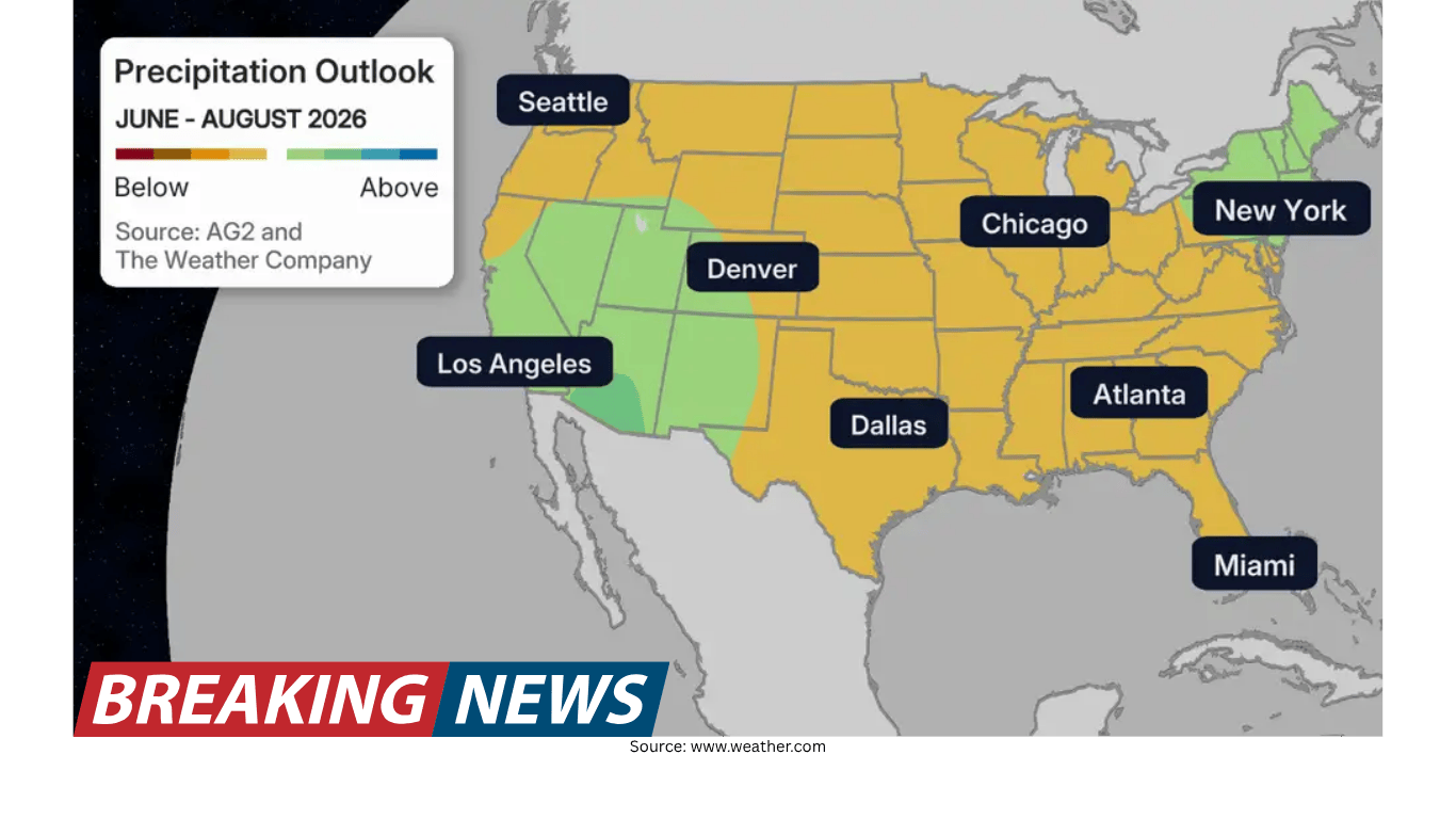
Summer precipitation outlook: concern during the hottest stretch
Long-term precipitation forecasts are not encouraging for the South and Southeast. A precipitation forecast for June through August points to below-average rainfall for both regions. While wetter conditions are forecast for May and June, the outlook is described as lacking rainfall during the height of summer.
That combination—drought already in place, followed by a summer period that may run drier than average—helps explain why a quieter hurricane season becomes part of the drought conversation. If tropical systems are less frequent, and if the core summer months also trend dry, the region could have fewer opportunities to make up precipitation deficits.
Why El Niño can mean fewer hurricanes
Historical patterns show that “super” El Niño years have seen far fewer hurricanes develop than years not defined as “super.” With a strong El Niño forecast to develop, that history supports the idea of a below-average hurricane season.
Storm tracks also tend to show patterns during these years, offering clues about where landfalls have typically occurred. Even so, it is crucial to treat these patterns as tendencies rather than guarantees. Seasonal outlooks describe probabilities, not certainties, and they cannot rule out significant landfalls.
Fewer storms does not mean zero impacts
Even if the season produces fewer hurricanes overall, impactful storms can still happen. It only takes one storm to make a season feel busy for a community, especially if that storm stalls, intensifies quickly, or brings heavy rain over vulnerable watersheds.
It is also important to remember that catastrophic flooding does not require a tropical system. Heavy rain can come from non-tropical setups, including slow-moving systems that draw in deep moisture and remain nearly stationary.
A reminder from Louisiana: extreme rain without a tropical system
The 2016 Louisiana floods illustrate how severe rainfall can occur without a named tropical cyclone. During Aug. 9–13, a slow-moving, non-tropical system moved through and produced extraordinary rainfall across southern Louisiana.
In Watson, Louisiana—about 20 miles northeast of Baton Rouge—31.39 inches of rain fell from the storm. Areas around Livingston received more than 2 feet of rainfall. The Amite River crested 5 feet above the previous record, spilling water into nearby towns.
Meteorologists said the event was fueled by a combination of well-above-average ocean temperatures in the Gulf and record levels of precipitable water values in the region. The storm sat nearly stationary for several days, producing more rainfall than the area had ever seen before.
This example underscores a key point for both drought and flood planning: the presence or absence of hurricanes is not the only factor that determines rainfall extremes. A season can be “quiet” in terms of named storms and still produce damaging rain events.
What this means for drought expectations
When a strong El Niño coincides with a forecast for fewer hurricanes, the South and Southeast may lose some of the rainfall that tropical systems can provide in an average year. Given that tropical systems can represent 10% to nearly 30% of seasonal precipitation in the southern region—and up to 20% to 30% in Florida, Louisiana, and North Carolina—a reduction in storm frequency can matter, especially when drought is already widespread.
At the same time, drought relief is not as simple as “more storms.” The most beneficial rainfall often comes from weaker systems moving at a moderate pace, and those conditions are not guaranteed in any season. Meanwhile, slow-moving systems—tropical or not—can bring destructive flooding rather than helpful replenishment.
The practical takeaway is that seasonal forecasts should be read in context. A below-average hurricane season may reduce one major hazard, but it does not automatically solve the region’s water challenges. In a year when drought coverage has expanded dramatically, the absence of tropical rainfall opportunities can become one more headwind.
Preparedness still matters—even in a quieter outlook
Despite the expectation of fewer hurricanes, preparedness remains essential. A single impactful storm can define a season for a household, a neighborhood, or an entire state. And because heavy rain and flooding can occur without a tropical system, planning only around named storms can leave gaps.
For residents across the South and Southeast, that means treating the season as you would any other: staying aware of changing forecasts, understanding local flood risk, and recognizing that drought and flooding can exist in the same broader climate story. A quiet hurricane season can still bring high stakes—just in different ways, and sometimes in the same week.
- Tropical systems can contribute about 10% to nearly 30% of seasonal precipitation across the southern region.
- Florida, Louisiana, and North Carolina can see about 20% to 30% of seasonal precipitation tied to tropical systems.
- Nearly 75% of the Southeast is experiencing “severe drought,” up from 3% a year ago.
- In the South, 86% of the region is in drought conditions, up from roughly 35% a year ago.
- June through August precipitation is forecast to be below average for the South and Southeast, even with wetter conditions forecast for May and June.
- Major flooding can occur without a tropical system, as shown by the Aug. 9–13, 2016 Louisiana event.