Rain and Mountain Snow Return to the West, Bringing Relief but Not a Full Recovery
A long-awaited change in the West’s weather pattern
Across the western United States, winter and early spring are typically the seasons when water resources are replenished—through a combination of rain at lower elevations and snow in the mountains. This year, however, that familiar rhythm was disrupted. Spring showers and mountain snowfall were described as severely lacking through the winter and into early spring, leaving many areas short on the moisture that normally accumulates during this time of year.
Now, a shift in the broader weather pattern is bringing what many have been waiting for: a return of precipitation to the West. The change is being framed as “much-needed relief,” a phrase that reflects both the dryness that preceded it and the importance of this moisture for the region. While the new pattern does not instantly reverse months of deficits, it does mark a meaningful turn toward wetter conditions—at least in the near term.
What the new pattern is delivering: rain below, snow above
The renewed moisture is not arriving in a single form. Instead, it is expected to fall as rain in lower elevations and as snow in higher terrain, particularly in the mountains. This division is typical of western precipitation events, where elevation and temperature determine whether moisture arrives as rainfall or accumulates as snowpack.
In Northern California, lower elevations are expected to receive the bulk of this moisture as rain, with totals of about 1 to 2 inches possible. For many communities, that amount is enough to be noticed—wet roads, fuller gutters, and a clear change from the drier pattern that dominated much of winter and early spring. While rain totals can vary from one location to another, the forecast range underscores that this is not merely a brief sprinkle; it is a more substantial round of precipitation.
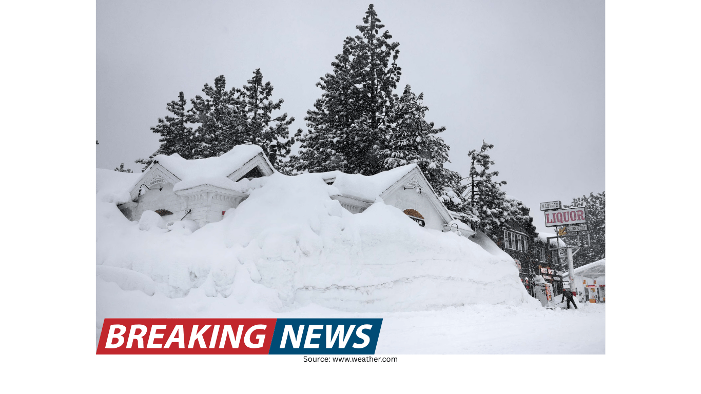
At the same time, the mountains are expected to see snowfall measured in feet. That detail is significant because mountain snowfall is more than just a scenic feature of the West. Snow that accumulates at higher elevations can later contribute to water availability as it melts, and it can help restore part of the deficit created by the earlier lack of snow.
Snowpack remains extremely low—even with feet of new snow
Even as the forecast calls for mountain snowfall measured in feet, the broader context remains sobering: snowpack is running extremely low. The return of snow is helpful, but it is arriving after a period when snow was “severely lacking,” meaning the baseline is already far below where it would typically be.
This is an important distinction for understanding what the new storm pattern can and cannot do. A single event—or even a short series of events—can provide relief and improve conditions, but it may not be enough to fully restore what was missed earlier in the season. When snowpack is extremely low, it often takes repeated storms and sustained snowfall over time to rebuild a meaningful reserve.
In other words, the coming snowfall can help restore some of the deficit, but it does not automatically signal a full recovery. The forecast offers a positive step, yet it also highlights the scale of what is still needed.
Why this moisture matters after a dry winter and early spring
The phrase “much-needed relief” captures the practical importance of the shift. When winter and early spring precipitation is missing, the effects can ripple across a region that relies on seasonal moisture. Rain and snow serve different roles, but both are central to the West’s annual cycle.
Rain at lower elevations can provide immediate, visible benefits: it moistens soils, supports vegetation, and reduces the sense of dryness that builds during extended rain-free stretches. It can also be a short-term boost for areas that have been waiting for spring showers that never fully arrived earlier in the season.
Mountain snow, meanwhile, is often discussed in terms of snowpack. Snowpack is essentially stored water, accumulating over time and persisting beyond the storm itself. When the snowpack is extremely low, the region loses part of that stored reserve. That is why feet of snowfall, while welcome, is being described as only a partial step toward restoring what was lost.
Northern California: 1–2 inches of rain possible at lower elevations
Among the specific details highlighted in the latest forecast is the potential for 1 to 2 inches of rain in Northern California at lower elevations. For residents, travelers, and anyone planning outdoor activities, that range can translate into a noticeable change in day-to-day conditions.
Rainfall in that amount can affect commutes and weekend plans, especially when it arrives after a long stretch of relatively dry weather. It can also be a reminder that the region’s weather can shift quickly, moving from a dry pattern to a wetter one that brings steady precipitation.
Because the moisture is expected to fall as rain at lower elevations, the same system that brings snow to the mountains may bring wet conditions to valleys and coastal areas. That contrast—snow above, rain below—is a defining feature of many western storm events, and it is central to understanding how one weather pattern can influence multiple landscapes at the same time.
In the mountains: snowfall measured in feet
Higher elevations are expected to receive snowfall measured in feet. That is a notable forecast detail because it suggests a more robust winter-like outcome in the mountains, even as the calendar moves through early spring.
For mountain communities and anyone watching snow totals, “measured in feet” implies accumulation that can quickly change conditions. Roads, trails, and mountain passes can be affected when snowfall adds up at that scale. At the same time, from a broader perspective, this type of snowfall is the kind that can begin to chip away at a snowpack deficit.
Still, it is crucial to keep the larger context in view: snowpack is extremely low, and there is still a long way to go. Feet of snow can help restore some of what is missing, but it may not be enough to fully compensate for the earlier lack of snow.
Relief, not resolution: what the forecast is—and isn’t—saying
The forecast narrative includes two ideas that need to be held together. The first is that the pattern has shifted to bring needed relief. The second is that much more is needed, and there is still a long way to go. Those statements are not contradictory; they describe different time scales.
In the short term, the return of precipitation can improve conditions and provide a boost to areas that have been unusually dry. In the longer term, however, the West’s water situation—reflected here in extremely low snowpack—depends on whether additional storms follow and whether the new pattern persists long enough to make a lasting difference.
This is why the forecast is careful to note that, although mountain snowfall will help restore some of the deficit, it does not erase the fact that snowpack is extremely low. The system is meaningful, but it is not portrayed as a cure-all.
Key takeaways from the latest update
Winter and early spring precipitation was severely lacking across the West, including spring showers and mountain snowfall.
A shift in the weather pattern is now bringing much-needed moisture to the region.
Snowpack remains extremely low, even as new mountain snowfall is expected to be measured in feet.
Mountain snow will help restore some of the deficit, but the overall shortfall remains significant and much more is needed.
Lower elevations are expected to see rain, with 1–2 inches possible in Northern California.
What to watch as the pattern evolves
When a region shifts from a dry pattern to a wetter one, the immediate question is often whether the change will last. The current forecast emphasizes that the pattern has shifted, and that the moisture arriving now is welcome. At the same time, the mention that there is still a long way to go suggests that the broader situation cannot be resolved by one round of storms.
For those tracking conditions in the West, two elements stand out in the latest information. First is the distribution of precipitation: rain for lower elevations and snow for the mountains. Second is the ongoing status of snowpack: extremely low, with improvement possible but far from guaranteed.
In practical terms, that means the coming precipitation can be viewed as an important step—one that provides relief and begins to address deficits—while also serving as a reminder that the season’s earlier lack of moisture left a gap that will take time and additional storms to close.
A turning point in the season, with more work left to do
The West is entering a period where the weather is offering something that was missing for much of winter and early spring: meaningful precipitation. Rain in Northern California could reach 1 to 2 inches at lower elevations, while mountain snowfall measured in feet is expected to help restore some of the deficit. Those are tangible developments, especially after a season described as severely lacking in both spring showers and mountain snow.
Yet the forecast also makes clear that this is not the end of the story. Snowpack is extremely low, and the region still has a long way to go. The current pattern shift brings relief, but it also highlights the scale of what has been lost—and the amount of additional moisture that would be needed to truly restore conditions.