Severe Weather Risk Builds Across the Plains, With Potential to Expand Into the Midwest
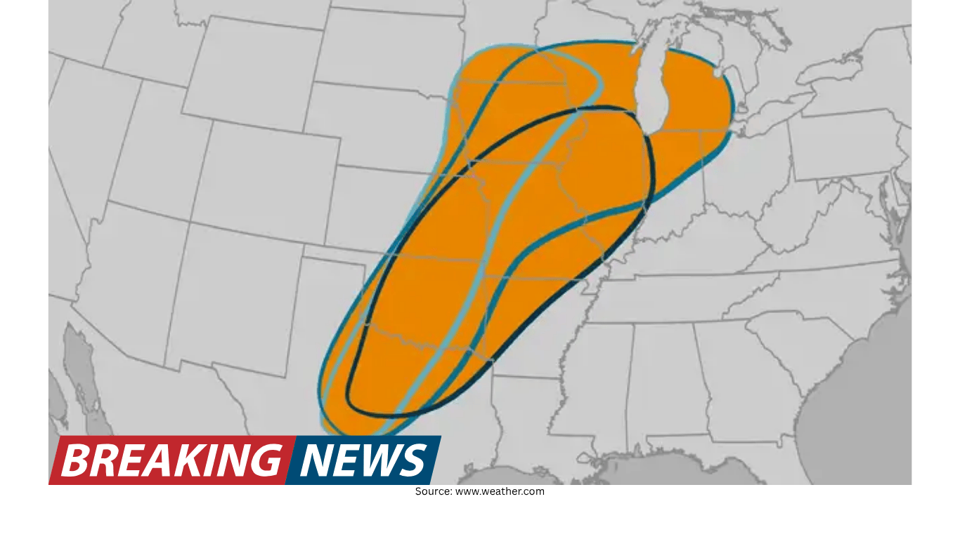
Severe thunderstorms are possible across portions of the Plains over the next few days, and the zone of concern may not stay confined to that region. Forecast guidance indicates the threat could also spread into parts of the Midwest and sections of the Mississippi River Valley by mid-week. For residents, travelers, and anyone with outdoor plans, the key message is that this is shaping up to be a multi-day period in which the risk of hazardous storms could shift from one area to another.
The primary threats highlighted for this stretch of weather include hail, strong wind gusts, and tornadoes. While not every community in the broader region will experience severe storms, the potential exists for multiple rounds of active weather, and the impacts can vary widely from one city to the next and from one day to the next.
Where the severe weather threat is focused
The Plains are expected to be the main area of concern early in the week. Several major population centers are included in the list of places that could see days of severe weather, underscoring how widespread the potential coverage may be.
Cities that could be affected during this period include:
- Dallas
- Oklahoma City
- Kansas City
- Chicago
- Des Moines
- Minneapolis
- Detroit
- St. Louis
This list spans from the southern Plains into the central Plains and onward into the Midwest, illustrating the possibility that the corridor of greatest risk may evolve as the week progresses. In practical terms, that means some locations could face one active day, while others could see repeated chances for storms over multiple days.
Timing: early week in the Plains, mid-week expansion possible
The overall timeline points to an early-week focus on the Plains, followed by a potential spread of the threat into parts of the Midwest and the Mississippi River Valley by mid-week. This type of progression matters because it can change which communities should be most alert on a given day.
For people planning travel between regions—such as driving from Texas into Oklahoma, or from Missouri toward Illinois and beyond—the shifting nature of the threat can be as important as the threat itself. A route that appears quiet one day could become more active the next as the risk area expands or relocates.
What “severe” could mean: hail, damaging winds, and tornadoes
The hazards associated with this forecast period include hail, wind gusts, and tornadoes. Each of these threats can produce different kinds of impacts, and storms may bring one or several hazards at the same time.
- Hail: Severe storms can produce hail that damages vehicles, roofs, and windows. Even brief hail bursts can create dangerous driving conditions.
- Damaging wind gusts: Strong thunderstorm winds can down tree limbs and power lines, and they can make travel difficult, especially for high-profile vehicles.
- Tornadoes: While tornadoes are not guaranteed in any one location, the forecast threat includes the possibility. Tornado risk is one of the reasons severe weather days require extra attention to warnings and shelter plans.
Because the threat includes tornadoes along with hail and strong winds, it is especially important for people in the potential impact area to be able to receive alerts quickly and to know where they would go if a warning is issued.
Why this forecast matters for large metro areas
Severe weather that targets major cities can have outsized effects, not only because of population density but also because of how many daily activities can be disrupted. The cities mentioned—ranging from Dallas and Oklahoma City to Chicago, Detroit, and Minneapolis—represent major transportation corridors and busy urban areas where storms can affect commutes, events, and airport operations.
Even when severe storms are scattered, the possibility of “days of severe weather” in multiple locations suggests a pattern in which the atmosphere may remain supportive of strong storms across a broad region for more than a single afternoon. That can complicate planning for schools, outdoor venues, and businesses that rely on predictable conditions.
How to use the forecast: stay flexible and stay informed
When severe weather is possible over several days, the most useful approach is to treat the forecast as a rolling situation. The overall message—severe storms possible in the Plains, with potential expansion into the Midwest and Mississippi River Valley by mid-week—provides a regional framework. But the details that matter most to individuals, such as which neighborhoods are in the highest risk zone and what time storms may arrive, often come into clearer focus closer to the event.
For anyone in or near the listed cities, it can help to build in flexibility. If you have outdoor plans, consider what you would do if storms develop earlier than expected or if warnings are issued during the time you plan to be outside. If you are traveling, consider that the most hazardous conditions may be localized but intense, and that delays can happen when storms move through.
City-by-city awareness: what to watch for
The forecast highlights a broad set of cities that could see severe weather during this period. While conditions will not be identical in each location, the inclusion of these metro areas provides a useful checklist for heightened awareness.
- Dallas: Located in a region that can experience severe storms during active patterns, Dallas is among the places that could see severe weather days in the coming stretch.
- Oklahoma City: With the Plains as an early-week focus, Oklahoma City is one of the cities that could be impacted as storms develop.
- Kansas City: As the threat potentially extends north and east, Kansas City is included among the areas that could see severe weather.
- Des Moines: Listed among the cities that could see severe weather, Des Moines may be affected as the threat reaches deeper into the Midwest.
- Chicago: The potential spread into the Midwest brings large metro areas like Chicago into the zone that could see severe storms by mid-week.
- Minneapolis: Minneapolis is also included among cities that could see days of severe weather, indicating the threat may reach well into the Upper Midwest.
- St. Louis: With parts of the Mississippi River Valley potentially in play by mid-week, St. Louis is one of the cities to monitor.
- Detroit: Detroit appears on the list of cities that could see severe weather, reflecting how far east the threat could extend into the Midwest.
In any of these locations, the most important step is to be ready for the possibility of rapidly changing conditions. Severe storms can develop quickly, and the difference between a routine thunderstorm and a severe one can be significant.
What “days of severe weather” can look like
The phrase “days of severe weather” suggests the possibility of more than one round of storms. For some communities, that could mean a severe threat on consecutive days; for others, it could mean a day with storms followed by a quieter period and then another active day later in the week. It can also mean that storms occur at different times of day from one day to the next.
This matters because repeated storm chances can wear down preparedness. People may pay close attention on the first day but become less vigilant if the first round is weaker than expected. However, when the overall pattern supports severe storms over multiple days, it is important to stay attentive throughout the period, not just during the first event.
Practical preparedness steps for hail, wind, and tornado threats
With hail, damaging winds, and tornadoes included among the possible hazards, preparation is less about predicting exactly what will happen at your address and more about ensuring you can respond quickly if warnings are issued.
- Know your safe place: Identify where you would go if a tornado warning is issued. The best option is typically an interior room on the lowest floor, away from windows.
- Have multiple ways to receive alerts: Because severe storms can develop and intensify quickly, it helps to have more than one method for receiving warnings.
- Plan for power disruptions: Damaging wind gusts can lead to outages. Consider what you would need if power is lost for a period of time.
- Protect vehicles when possible: Hail can be a primary driver of property damage in severe storms. If you have access to covered parking, it may be worth using when storms are expected.
- Adjust outdoor plans: If you have events, sports, or work outside, consider how you will get to shelter quickly if storms approach.
These steps are broadly applicable across the Plains, Midwest, and Mississippi River Valley during severe weather periods, and they become especially relevant when the forecast indicates multiple days of potential storms.
Bottom line
The forecast calls for a period of possible severe storms across the Plains over the next few days, with the threat potentially spreading into parts of the Midwest and the Mississippi River Valley by mid-week. Hazards may include hail, damaging wind gusts, and tornadoes. A number of major cities—Dallas, Oklahoma City, Kansas City, Chicago, Des Moines, Minneapolis, Detroit, and St. Louis—are among those that could see days of severe weather.
As the situation evolves, the most useful approach is to stay aware of changing conditions and be prepared to act quickly if severe weather warnings are issued in your area.