Thunderstorms, Heavy Rain and Strong Winds Forecast for Parts of Pahang, Sarawak and Sabah Until 1pm
Warning issued for thunderstorms, heavy rain and strong winds
A weather warning for thunderstorms, heavy rain and strong winds has been issued for parts of Pahang, Sarawak and Sabah, with the alert in effect until 1.00pm today. The advisory covers selected districts across the three states, reflecting conditions that may bring intense downpours and potentially disruptive weather within a short time frame.
The warning was issued on 18 February in Kuala Lumpur by the national meteorological authority, which monitors atmospheric conditions and provides public updates when severe weather is likely or already occurring. The notice is intended to help residents and those travelling through affected areas stay aware of changing conditions through midday.
Areas affected in Pahang
In Pahang, the warning applies to several locations along the state’s eastern corridor. The districts named in the advisory are:
- Kuantan
- Pekan
- Rompin
These areas may experience thunderstorms accompanied by heavy rain and strong winds during the warning period. While the alert is time-limited to 1.00pm, the conditions described can develop rapidly, particularly when thunderstorm clouds build and intensify.
For communities in Kuantan, Pekan and Rompin, the combination of heavy rainfall and gusty winds can create difficult conditions on roads and in open areas. Even within a few kilometres, rainfall intensity can vary significantly during thunderstorms, making it important for people to remain attentive to local conditions as they change.
Areas affected in Sarawak
In Sarawak, the warning includes districts in the state’s southwest. The locations listed are:
- Kuching
- Samarahan
- Asajaya
The advisory indicates that these areas are at risk of thunderstorms with heavy rain and strong winds through 1.00pm. In practice, thunderstorm activity can bring brief periods of very heavy rainfall, sometimes alternating with lighter rain or short breaks, depending on how storm cells move and evolve.
Residents and commuters in Kuching, Samarahan and Asajaya may notice darkening skies, increasing wind, and sudden bursts of rain as thunderstorms develop. The warning is designed to provide a clear time window for heightened caution, especially during late morning and early afternoon hours when people may be travelling, working outdoors, or managing daily errands.
Areas affected in Sabah
In Sabah, the warning covers parts of the east coast. The districts specified are:
- Kinabatangan
- Sandakan
Thunderstorms, heavy rain and strong winds may affect Kinabatangan and Sandakan until 1.00pm. As with other thunderstorm-related advisories, the most intense conditions can occur over a relatively short duration, but may still have immediate impacts on visibility and travel conditions.
For those in Kinabatangan and Sandakan, the warning serves as a prompt to plan movements carefully during the period stated, particularly if travel involves exposed roads or areas where weather can change quickly. Strong winds associated with thunderstorms can also accompany heavy rain, increasing the potential for sudden squalls.
What the warning is based on
According to the meteorological authority, the warning is issued when there are signs of thunderstorms with rainfall intensity exceeding 20 millimetres per hour that are either imminent or expected to continue for more than one hour. This threshold helps forecasters identify storms that may produce particularly heavy bursts of rain, rather than lighter, intermittent showers.
The emphasis on rainfall intensity is important because it signals the potential for rapid accumulation within a short time. When rain falls at a rate above 20 millimetres per hour, conditions on the ground can change quickly—roads can become slick, visibility can drop, and outdoor activities may be disrupted. The additional note that the conditions may persist beyond an hour suggests that the weather could remain unsettled for a sustained period within the warning window.
Understanding the time frame: “until 1.00pm”
The warning is valid until 1.00pm, indicating the period during which the specified conditions are anticipated in the named districts. Weather warnings are time-bound because thunderstorm development can be highly dynamic, and forecast confidence is typically strongest over shorter periods.
However, a time limit does not necessarily mean weather will stop precisely at that moment. Instead, it reflects the latest point up to which the warning is currently assessed to be necessary based on available observations and expectations of storm behaviour. Conditions may weaken earlier in some places, or remain active in others, depending on how storm cells develop and move.
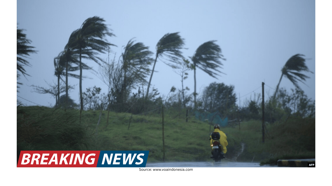
Why thunderstorms can bring both heavy rain and strong winds
Thunderstorms are often associated with intense rainfall and gusty winds because of the way air moves within storm clouds. While the warning focuses on the expected impacts—heavy rain, thunderstorms and strong winds—the combination is typical of convective storms that can produce sudden changes in weather over short distances.
During a thunderstorm, rain can fall in heavy sheets, sometimes accompanied by wind gusts that arrive abruptly. This is one reason warnings are issued for specific districts: thunderstorm impacts are frequently localised, and the most severe conditions may occur in a narrow corridor while nearby areas experience lighter effects.
District-by-district summary
For clarity, the warning areas can be grouped by state as follows, all valid until 1.00pm:
- Pahang: Kuantan, Pekan, Rompin
- Sarawak: Kuching, Samarahan, Asajaya
- Sabah: Kinabatangan, Sandakan
This list is intended to help readers quickly identify whether they are within the districts named in the advisory. People outside these areas may still experience rain or stormy conditions, but the warning specifically targets locations where signs point to thunderstorms with heavier rainfall intensity.
What people in affected areas may notice
Although the warning does not provide a minute-by-minute forecast, thunderstorms of the type described are commonly accompanied by noticeable changes in the weather. People in the affected districts may observe:
- Rapidly darkening skies and thick cloud cover
- Sudden heavy rainfall that reduces visibility
- Gusty winds that strengthen as storm cells pass through
- Thunder and lightning during periods of intense rain
Because the advisory is tied to rainfall intensity above 20 millimetres per hour and the possibility of persistence beyond an hour, the heaviest downpours may arrive in bursts and may not be uniform across the entire district. Conditions can also shift quickly, so it is common for one area to experience intense rain while another nearby location sees lighter rainfall at the same time.
Staying aware during the warning period
Weather warnings are issued to support public awareness during potentially hazardous conditions. With the current alert in place until 1.00pm, people in the named districts may consider adjusting schedules that involve outdoor movement or travel if conditions deteriorate. The combination of heavy rain and strong winds can make short trips more challenging, particularly during the peak of a thunderstorm.
For those who must travel, the most immediate concern during heavy rain is often reduced visibility. Strong winds can also accompany downpours, and thunderstorm conditions can change rapidly over a short period. Remaining attentive to the weather around you—especially when rainfall intensifies—can help reduce exposure to the worst conditions during the warning window.
How warnings are typically triggered
The meteorological authority notes that the warning is issued when there are signs of thunderstorms with rainfall intensity exceeding 20 millimetres per hour that are about to occur or are expected to continue for more than an hour. This description points to two key elements: the intensity of rainfall and the likelihood of persistence.
In practical terms, a storm that meets this threshold can produce heavy rain quickly. The “expected to continue” element suggests that the storm is not only intense but may also maintain that intensity long enough to affect daily routines and travel plans during the late morning period.
Key takeaways
- A warning for thunderstorms, heavy rain and strong winds is in effect until 1.00pm today.
- Affected districts are Kuantan, Pekan and Rompin in Pahang; Kuching, Samarahan and Asajaya in Sarawak; and Kinabatangan and Sandakan in Sabah.
- The warning is issued when signs indicate thunderstorm rainfall intensity above 20 millimetres per hour that is imminent or likely to persist for more than an hour.
As midday approaches, conditions may vary by location, but the warning highlights the potential for intense rainfall and stormy weather in the specified districts within the stated time frame. People in these areas may wish to remain alert to local weather changes through 1.00pm.