What a “Super El Niño” Could Mean for Weather Across the United States
El Niño is expected to form later this year
El Niño is expected to form later this year, a development that often draws attention well beyond the Pacific Ocean where it begins. That’s because El Niño is closely watched for its potential to influence weather and climate patterns across the United States. As forecasts and conversations build around the upcoming event, one question tends to surface quickly: what are the chances it could become a “super El Niño,” and what would that mean?
While the phrase “super El Niño” can sound dramatic, it is fundamentally a way of describing an especially strong version of El Niño. Meteorologist Jennifer Gray has explained what a super El Niño is and why it matters, focusing on how an unusually intense event could shape weather and climate across the U.S. The key point is not that a super El Niño guarantees any single outcome in any specific city, but that it can shift the odds for certain patterns on a national scale.
What El Niño is—and why strength matters
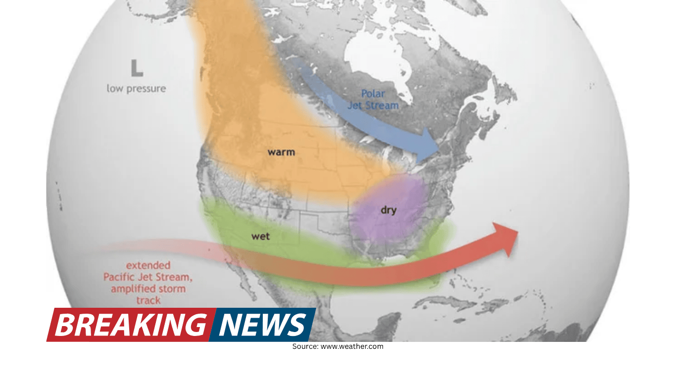
El Niño is a climate pattern that forms in the Pacific and can affect weather and climate far away, including across the continental United States. When El Niño is expected to form later in the year, it becomes a central topic for seasonal outlooks because it can act like a background signal in the atmosphere—one that can tilt broader patterns in one direction or another.
The idea of a “super El Niño” is tied to the strength of that signal. In simple terms, the stronger the El Niño, the more likely it is to have a noticeable influence on large-scale weather and climate patterns. That does not mean every region experiences the same effects, and it does not mean the atmosphere follows a script. But it does mean forecasters pay close attention to the possibility of an unusually strong event because it can increase the potential for widespread impacts.
Defining “super El Niño” in practical terms
The term “super El Niño” is used to describe an El Niño event that is particularly strong compared with typical events. It’s a way of separating a standard El Niño from one that could exert a more pronounced influence on weather and climate patterns.
In public discussions, the phrase can be misunderstood as a guarantee of extreme weather everywhere. In reality, it is best understood as a description of intensity—an indicator that the underlying climate pattern may be more powerful than usual. Meteorologist Jennifer Gray has focused on explaining what qualifies as a super El Niño and what that could mean for the United States in terms of broad weather and climate influences.
What a super El Niño could mean for the United States
Because El Niño can influence weather and climate across the U.S., the prospect of a super El Niño naturally raises the stakes for seasonal planning. A stronger event could have a larger footprint in terms of shifting patterns, affecting how weather systems behave over weeks and months rather than day-to-day forecasting.
It’s important to keep the scope of the discussion clear. The expected formation of El Niño later this year is a forecast about a developing climate pattern, not a specific storm prediction. Likewise, asking about the chances of a super El Niño is about whether the event could become unusually strong, which would increase the potential for more noticeable pattern changes.
Jennifer Gray’s explanation centers on the idea that a super El Niño could shape weather and climate across the U.S. That influence can show up in the way seasonal conditions evolve, how persistent certain patterns become, and how the atmosphere distributes storms and temperature swings over time.
Why meteorologists talk about probabilities, not promises
Seasonal climate signals like El Niño are often discussed in terms of probabilities. Even when El Niño is expected to form later in the year, there is still variability in how it develops and how the atmosphere responds. When people ask about the chances of a super El Niño, they are asking about the likelihood of an especially intense event, but also indirectly asking how confident forecasters can be about downstream impacts.
That’s why meteorologists emphasize what an event “could mean” rather than what it “will mean.” A super El Niño can strengthen the background influence on weather and climate patterns, but it does not eliminate other factors that can shape U.S. weather. The atmosphere is complex, and even strong climate patterns interact with other processes that can amplify, weaken, or redirect their effects.
How this connects to forecasting and public expectations
When a well-known climate pattern is expected to form, it can shape public expectations about the coming seasons. People may wonder whether it signals a major change from recent conditions or whether it increases the risk of disruptive weather. The term “super El Niño” can intensify those expectations, which is why clear explanations matter.
Jennifer Gray’s focus on defining what a super El Niño is helps ground the conversation in meteorology rather than hype. The practical takeaway is that a stronger El Niño could have broader implications for weather and climate across the U.S.—a reason for attention, not alarm.
What to watch as El Niño develops
With El Niño expected to form later this year, the most relevant question becomes how it evolves over time. Strength is a key variable, and the difference between a typical El Niño and a super El Niño is meaningful because it can alter how strongly the pattern influences U.S. weather and climate.
As the event develops, meteorologists will keep refining their assessments. The conversation about “chances” reflects the reality that the atmosphere is dynamic, and the final outcome depends on how conditions unfold. The main point remains consistent: El Niño can influence weather and climate across the United States, and a super El Niño is an especially strong version of that pattern that could make the influence more pronounced.
Practical ways to use this information
For many people, the value of understanding El Niño is not in predicting a specific day’s weather months in advance, but in appreciating how the seasonal backdrop may shift. If El Niño forms as expected later this year, and if it were to become unusually strong, it could affect the overall character of weather and climate patterns across the U.S.
That can be useful context for anyone making longer-range decisions—whether that involves travel planning, budgeting for seasonal energy use, or simply staying informed about the factors that shape the country’s weather. The emphasis should remain on preparedness and awareness rather than certainty, since even strong climate patterns do not dictate exact outcomes everywhere.
Key points at a glance
El Niño is expected to form later this year.
A “super El Niño” refers to an especially strong El Niño event.
El Niño can influence weather and climate across the United States.
A stronger event could mean a more noticeable influence on U.S. weather and climate patterns, though it does not guarantee specific local outcomes.
Meteorologist Jennifer Gray has explained what a super El Niño is and what it could mean for the U.S.
Bottom line
El Niño’s expected formation later this year puts renewed focus on how the Pacific can shape weather and climate far from its origin. The question of whether it could become a super El Niño is ultimately a question of intensity and influence: an unusually strong event could have broader implications for weather and climate patterns across the U.S. Understanding that distinction—between a climate pattern that shifts odds and a forecast that guarantees outcomes—helps keep the conversation clear, practical, and grounded in what meteorologists can responsibly say.