Why Some El Niño Hurricane Seasons Still Produce Early Storms
El Niño and the “early storm” surprise
The Atlantic hurricane season has an official start date of June 1, a marker that helps emergency managers, forecasters, and coastal residents align preparations with the time of year when tropical development becomes most likely. Yet the atmosphere does not follow a calendar. Even in years when a developing El Niño suggests the season as a whole may be below average, tropical storms can still form in late May—or even earlier—creating a confusing contrast between seasonal outlooks and what people see on the map.
This apparent contradiction has shown up in recent history. Some stronger El Niño seasons have featured pre-season storms, a reminder that the same large-scale pattern that can suppress hurricane activity later in the summer does not necessarily prevent tropical systems from forming in the weeks leading up to June 1. In other words, an El Niño signal can point toward reduced overall activity while still leaving room for a brief early-season “curveball.”
What “below average” does—and does not—mean
Seasonal hurricane forecasts often focus on how many named storms, hurricanes, or major hurricanes might occur across the full season. In years when a super El Niño is developing, the broader expectation is typically for reduced Atlantic activity. That outlook is rooted in the atmospheric pattern El Niño tends to promote, including wind shear that can make it harder for tropical systems to organize and strengthen.
However, an important nuance is timing. Early in the season, the wind shear associated with El Niño may not have fully established itself across the regions where storms might try to form. That can open a small window in late spring when the Atlantic basin can still produce a named storm, even if the overall seasonal environment later becomes less favorable for frequent development.
So when an early storm forms during an El Niño year, it should not automatically be interpreted as evidence that a busy season is underway. It may simply reflect that the atmosphere briefly supported development before the more suppressive elements of the pattern became dominant.
Recent examples of pre-season storms during El Niño years
Two recent storms illustrate how early or borderline pre-season systems can occur even when El Niño is part of the climate backdrop. These examples also show that early storms can take different paths and produce different impacts, despite often being weaker than peak-season hurricanes.
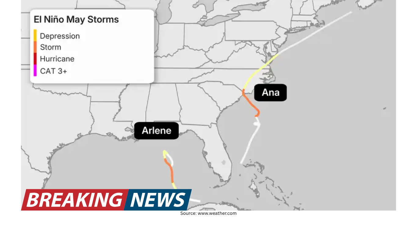
Tropical Storm Arlene (2023): Arlene was active in the Gulf during the last few days of May, even though it was not classified as a tropical system until June 1. The storm was short-lived, surviving until June 3. It traveled south before fizzling out and did not make a direct U.S. landfall.
Tropical Storm Ana (2015): Ana formed on May 8 and made landfall along the South Carolina coast on May 10 near Myrtle Beach. It brought winds of about 45 mph and more than 6 inches of rain. Several homes were flooded, and a few water rescues took place during the storm’s interaction with South Carolina. Ana was noted as the earliest recorded tropical system to make landfall in the U.S.
These storms underscore a key point: “early” does not necessarily mean “strong,” but it can still mean “impactful,” especially when heavy rainfall is involved. Ana, in particular, demonstrates how a system that is not a major hurricane can still lead to flooding and emergency response needs.
How early-season storms can form
Late spring does not usually resemble the heart of hurricane season. Sea-surface temperatures, jet stream patterns, and the distribution of thunderstorm activity differ from what is typical in August and September. Still, there are recurring setups that can help a tropical or subtropical system develop close to the U.S. coastline before June 1.
Two pathways are especially common in early-season development:
1) Low pressure drifting into warm water
In spring, areas of low pressure frequently move across the southeastern United States. This pattern can bring rounds of severe weather, which is typical for the season. Sometimes, however, a low-pressure system can drift southward into the Gulf, where it encounters warm water. When that happens, the system may begin to acquire tropical characteristics.
Early-season storms that form this way often develop relatively close to shore. Because of that, there is frequently not much time between formation and potential landfall. These systems also tend to be weaker in nature, in part because the broader environment is not as consistently supportive as it is during the peak months.
2) A stalled frontal boundary near the Southeast coast
Another common setup involves a stalled frontal boundary. During spring, fronts do not always push cleanly off the Southeast coast. When a front stalls, it can create a persistent zone of unsettled weather over warm water in the Gulf or the western Atlantic.
This unsettled pattern can provide a window for a disturbance to organize. As with low-pressure-driven development, storms that form along stalled fronts often spin up close to the coast and are typically weaker. But “weaker” does not mean “harmless,” particularly when rainfall becomes the main hazard.
Why weak storms can still be dangerous
Early-season tropical systems are often compact and close to land. That combination can heighten certain risks, even if winds remain below hurricane strength. One of the most significant threats is flash flooding. Quick-developing systems can deliver heavy rain, and if the storm is a slow mover, rainfall totals can add up rapidly.
The impacts described with Tropical Storm Ana—flooded homes and water rescues—highlight how rain can become the defining hazard. These events can unfold quickly, especially when a storm develops near the coastline and communities have limited lead time to prepare.
Early storms don’t predict the rest of the season
It can be tempting to treat the first named storm as a signal of what is to come. But the timing of the first storm has little correlation with how active the full season becomes. Some years that feature May storms go on to be relatively quiet. Other years that start late can still end up extremely active.
What ultimately shapes the season is the broader atmospheric pattern over the months that follow. Factors such as wind shear, ocean temperatures, and thunderstorm activity in the tropics are central to how many storms form and how strong they become. During super El Niño seasons, that overall environment is typically less favorable for Atlantic tropical activity, even if a brief early-season window allows a storm to develop.
Staying aware outside the peak months
The peak of Atlantic hurricane season is commonly associated with August and September, when ocean warmth and tropical moisture are at their most supportive. Early-season systems, by contrast, may form through different mechanisms and may not “play by the same rules” as storms that develop deep in the tropics later in the summer.
That difference is one reason early storms can catch people off guard. A disturbance tied to springtime weather patterns can transition into a tropical system near the coast, leaving little time to adjust plans. Even when forecasts call for a below-average season overall, it remains sensible to stay aware of developments as the calendar approaches June—particularly in coastal areas that can be affected by fast-forming systems.
Bottom line
El Niño is often associated with a quieter Atlantic hurricane season, especially when a super El Niño is developing. But that seasonal tendency does not eliminate the possibility of a pre-season storm. In late spring, the wind shear that typically suppresses storms during El Niño years may not have fully taken hold, and certain setups—such as a low-pressure system drifting into the Gulf or a stalled frontal boundary offshore—can allow a tropical storm to form close to land.
Recent storms like Arlene (2023) and Ana (2015) show how early systems can emerge around the edges of the official season and still produce real impacts, particularly from heavy rainfall and flooding. The presence of an early storm, however, is not a reliable indicator of a busy season ahead. The broader pattern of wind shear, ocean temperatures, and tropical thunderstorm activity ultimately determines how the season unfolds.