Winter Storm Hernando Loosens Its Grip, But Wind, Ice and Outages Keep Northeast on Edge
Winter Storm Hernando is beginning to ease in some parts of the Northeast, but the region’s challenges are far from over. While the storm’s heaviest snowfall has largely ended, strong winds are expected to continue blowing overnight into Tuesday, creating the risk of near-whiteout conditions as snow drifts back across roads and sidewalks. Thousands of people are also dealing with power outages, and officials in multiple states continue to urge residents to avoid unnecessary travel.
The storm has been described as a “bomb cyclone,” a rapidly intensifying low-pressure system that can bring a hurricane-like appearance on satellite imagery, along with powerful winds and heavy precipitation. In this case, the precipitation has been snow—often heavy and wet—compounding impacts ranging from downed trees and damaged power infrastructure to dangerous road conditions. At least two deaths have been associated with the storm, and emergency declarations were issued by governors in seven states as winter weather alerts spread across a wide swath of the region.
What changes as the snow winds down
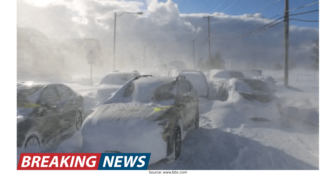
By Monday evening, the heaviest snow from Winter Storm Hernando had finished for many locations. However, the storm’s winds across the Northeast were expected to continue blasting overnight. That matters because drifting snow can rapidly reduce visibility, and even after plows pass, roads can become snow-covered again as gusts push snow back into travel lanes.
Some blizzard warnings across the coastal Northeast were set to expire Monday evening, including in major cities such as New York and Portland, Maine, as snowfall began to taper. But the situation remained uneven. Less-protected areas—particularly those more exposed to the wind—could still see blizzard conditions into early Tuesday. Boston, for example, was expected to remain under a blizzard warning until Tuesday morning at 7 a.m. EST.
Officials continued to recommend avoiding travel if possible. For those who must go out, the guidance remained consistent: allow extra time, move cautiously, and anticipate rapidly changing conditions as snow drifts and refreezing create slick surfaces.
Power outages: improving in some places, but still widespread
One of the most persistent impacts of Hernando has been the loss of electricity across multiple states. Outages began dropping for the first time since the storm started, but service disruptions remained significant—especially in areas where heavy snow and strong winds continued.
Massachusetts was the hardest hit. At one point, more than 282,000 customers in the state were without power, representing about half of all outages linked to Hernando. Reports also noted outages nearing 290,000 statewide. New Jersey followed with about 93,000 outages.
Across the broader region, more than 650,000 customers were without power nationwide, according to outage tracking data cited in the updates. With extremely cold temperatures in play, officials warned that outages could be long lasting in some locations, particularly where damage to poles and lines was severe. Nantucket was highlighted as one area where restoration could take time, as video showed power poles covered in snow, snapped, and lying by the roadside.
Travel disruptions and the “ripple effect” beyond the storm zone
Even as the storm’s core impacts were concentrated along the Eastern Seaboard, the disruptions spread well beyond the Northeast. The storm triggered a cascade of flight cancellations nationwide, creating knock-on effects for travelers far from snow-covered streets.
Since the storm began, more than 9,900 flights were canceled nationwide, with hundreds more already canceled for the next day, according to flight tracking data referenced in the updates. Another report placed cancellations at more than 10,000 from Sunday through Tuesday, including more than 5,300 cancellations on Monday alone and about 1,300 already canceled for Tuesday. Even Salt Lake City saw more than 40 flights canceled due to the storm, despite a forecast there calling for sunny skies and temperatures in the 50s—an example of how aircraft and crews displaced by weather can disrupt schedules across the country.
On the ground, officials warned that the region could remain in “a bit of chaos” into Tuesday due to days of cancellations and closures. That includes delayed reopenings, difficult commutes, and the slow process of clearing streets, sidewalks, and transit hubs.
Why this storm is called a bomb cyclone
Hernando’s designation as a bomb cyclone stems from how quickly it intensified. Bomb cyclones form when a low-pressure system strengthens rapidly, often when cold air interacts with warmer ocean waters. The result can be a dramatic storm structure visible on satellite imagery, with powerful winds and heavy precipitation.
Although bomb cyclones can resemble hurricanes in appearance and can have central pressures comparable to strong tropical systems, the underlying mechanics differ. Hurricanes draw energy from warm tropical waters and have a warm core. Bomb cyclones are cold-core systems and typically develop at higher latitudes. In Hernando’s case, the storm’s central pressure was described as similar to that of a Category 2 hurricane, but it remained cold-core rather than warm-core.
One update noted the storm’s central pressure dropped by about 40 millibars in 12 hours—well beyond the threshold used to define a bomb cyclone—and that it met the requirement in about nine hours.
Blizzard conditions: more than “a lot of snow”
As blizzard warnings remained active in some areas, meteorologists emphasized that a blizzard is not simply a heavy snowstorm. The National Weather Service definition requires specific criteria to be met simultaneously, including strong winds and significantly reduced visibility for a sustained period.
Importantly, blizzard conditions can occur even without new snow falling. If winds remain strong enough to blow existing snow into the air, visibility can drop to dangerous levels. That distinction matters as Hernando’s snowfall tapers: the end of steady accumulation does not necessarily mean the end of hazardous conditions.
Snowfall totals and record territory
Hernando produced striking snowfall totals across parts of the Northeast and Mid-Atlantic, with some locations approaching or surpassing notable records. In and around New York City, Central Park recorded just over 15 inches of snow—its heaviest snowstorm in just over five years, since a 17.4-inch event from late January to early February 2021. Meteorologists noted that if the city added another 2.4 inches, Hernando would rank as the heaviest snowstorm there since a 27.5-inch storm in late January 2016.
Snowfall rates were also intense. Reports cited snow falling at about 1 inch per hour at LaGuardia Airport and 2 inches per hour at JFK International Airport. On Long Island, a National Weather Service office reported a snowfall rate of 3 inches per hour earlier in the day.
Providence, Rhode Island, stood out for extraordinary totals. T.F. Green Airport officially reported a two-day snowfall total of 32.8 inches, making it the snowiest two-day period on record there, surpassing the previous record of 28.6 inches from the “Blizzard of ’78.” The airport also reported 30.4 inches in a single day, breaking the prior one-day record of 19 inches that ended Jan. 8, 1996. Another update described a roughly 32-inch snow depth change since the storm began, with snowfall rates estimated around 4 inches per hour during the height of the event, while noting that official totals were still being finalized.
New Jersey also saw significant accumulation, including an official 24.2 inches on the ground in Freehold Township, placing it in rare territory for the storm.
Why some areas were buried: stalled snowbands
One explanation for the extreme totals in certain corridors comes down to snowband behavior. The most prolific snowfalls outside higher elevations often occur when intense snowbands stall over the same area for hours. That pattern was observed along the Eastern Seaboard from Delaware to southern New England.
Radar comparisons from early morning into late morning showed heavy bands of snow that “hardly moved” along the East Coast. When that happens, snowfall accumulates quickly, and the combination of heavy rates and persistent wind can overwhelm plowing operations and emergency response.
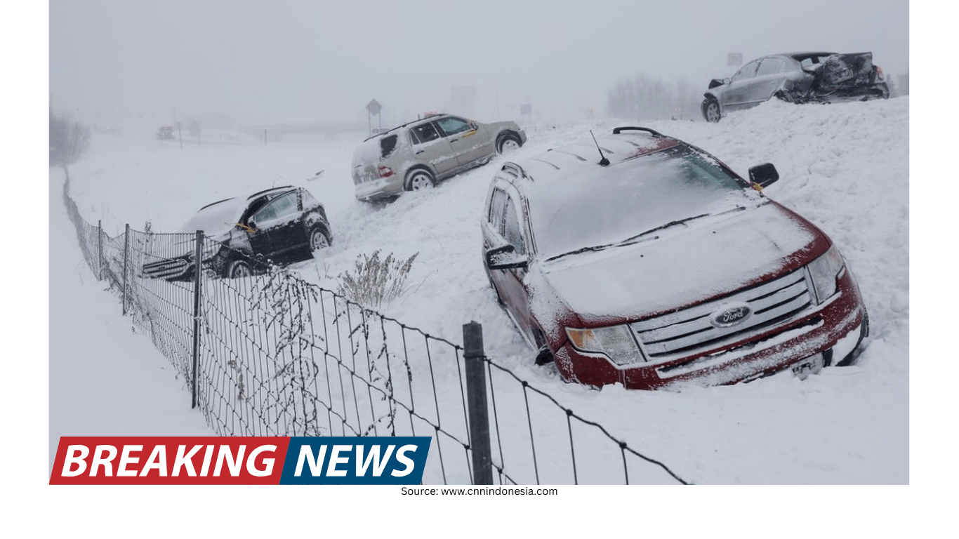
Road conditions and emergency measures
Across the region, officials described travel conditions as dangerous, with visibility at or near zero in some places. In Massachusetts, Gov. Maura Healey issued an immediate ban on all non-essential motor vehicle travel in the southern coast of the state. A 40 mph speed limit was also put in place on the Massachusetts Turnpike. Officials warned that conditions were life-threatening, that plows were struggling to keep up, and that ongoing rescue operations had been suspended.
Elsewhere, the impacts were measurable in emergency response statistics. In Maryland, state police reported handling more than 1,190 calls for service and responding to nearly 343 crashes as snow made roads slick. About 4 inches fell in Baltimore, with parts of Baltimore County seeing close to 5 inches, according to the National Weather Service. Nearly 30% of Maryland’s calls came from the Eastern Shore, where a Blizzard Warning remained in effect through Monday evening due to strong wind gusts.
In New York City, officials said every street had been plowed at least once. But with snow still falling and winds whipping it around, residents were warned that it might not look like crews had been through. Plows continued making rounds, and authorities cautioned that roads could remain slick even after a citywide travel ban was lifted.
Digging out: plows, shovelers, and the refreeze problem
Even after the snowfall slows, the work of recovery can take days. Meteorologists warned that travel could remain difficult due to partial snowmelt followed by refreezing, which can turn slush into ice and create hazardous driving and walking conditions.
In New York City, snow removal extended beyond plowing. The city deployed 575 emergency snow shovelers overnight to clear key pedestrian infrastructure, including 1,500 crosswalks, 400 fire hydrants, and 900 bus stops. Emergency shovelers are hired during major storms, with pay starting at $19.14 an hour and rising to $28.71 an hour after the first 40 hours worked in a week.
In other places, the sheer depth and density of the snow created obstacles even for equipment. Providence-area reports said some smaller plows were getting stuck in the heavy snow, underscoring how difficult it can be to keep roads passable when snowfall rates are extreme.
Heavy, wet snow and its hazards
Not all snow is the same, and Hernando delivered snow that was frequently described as heavy and wet. With temperatures hovering around or just below freezing, the air can hold more moisture, leading to denser snow that clings to trees and power lines and is harder to shovel.
This type of snow is sometimes nicknamed “heart-attack snow” because of the strain it can place on the cardiovascular system during shoveling. The heavier the snow, the more effort it takes to move, and the more important it is to take extra care before heading outside to clear driveways and sidewalks.
Heavy snow loading also contributed to damage reports. In Massachusetts, the weight of the snow brought down trees, creating hazards on roadways. In Pennsylvania, images showed tree damage in King of Prussia, northwest of Philadelphia.
Coastal flooding: a secondary concern around high tide
Along the coast, the threat of coastal flooding was another factor. Officials noted that coastal flooding had already peaked during the day Monday, but the high tide early Tuesday morning could push some monitoring sites along the Northeast coast back into action stage or minor flood stage, based on guidance from federal water prediction services.
This risk can persist even as snowfall decreases, particularly when strong winds and low pressure continue to influence water levels. Residents in coastal areas were urged to stay alert to local advisories and conditions.
Schools and public services: closures, snow days, and reopenings
The storm closed dozens of school districts across the Northeast, including some of the nation’s largest systems. New York City and Boston were among the major districts affected, with Boston canceling classes for Tuesday in multiple districts.
New York City public schools were set to reopen Tuesday, the mayor announced Monday afternoon. The closure was described as the city’s first true, traditional snow day with no remote learning since before the pandemic in 2019. Officials noted that a waiver was needed, and that timing around the end of a break created challenges because many students did not have devices at home. The storm also stranded some families and teachers during vacation travel amid widespread flight cancellations.
What to watch next
As Hernando pulls away from the coast, the Northeast’s immediate focus shifts from peak snowfall to lingering wind, drifting, and the slow process of restoring normal routines. In some places, additional snow was still forecast on top of what had already fallen, and meteorologists noted that more was expected for parts of the region after Monday.
For many communities, the next several days will likely be defined by a combination of cleanup and caution: plowing and shoveling as conditions allow, careful driving as temperatures fluctuate and roads refreeze, and patience as utility crews work through widespread outages. With blizzard conditions possible even after steady snowfall ends, officials continued to stress a simple message for those in the storm’s path: stay safe, stay warm, and keep up with local announcements.
- Strong winds can keep visibility low even after snowfall tapers due to drifting snow.
- Roads may become icy as partial melting refreezes, extending travel hazards for days.
- Power restoration could take time in the hardest-hit areas, especially where poles and trees were damaged.
- Coastal locations may see renewed flooding concerns around high tide.
- Flight disruptions may continue nationally as airlines reposition aircraft and crews.