Severe Weather Threat Returns for Parts of the South and Midwest as Multi-Day Storm System Unfolds

A renewed severe weather setup across multiple regions
A new round of severe weather is expected to unfold over the next three days, with storms and isolated flash flooding forecast to affect several parts of the country. The event begins in the Southeast and then expands and shifts, bringing a mix of hazards that can change quickly from one day to the next.
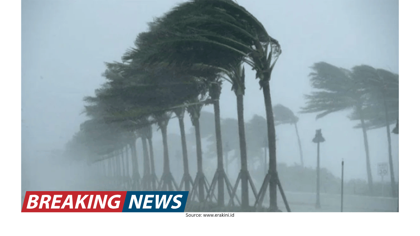
Forecasters are watching for a combination of threats that can include strong wind gusts, large hail, tornadoes, and flooding. While not every community will experience the same impacts, the multi-day nature of the pattern means residents in more than one region may need to stay alert as the focus of the risk migrates.
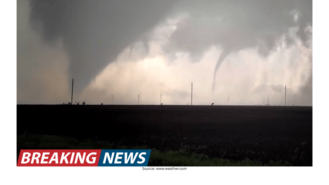
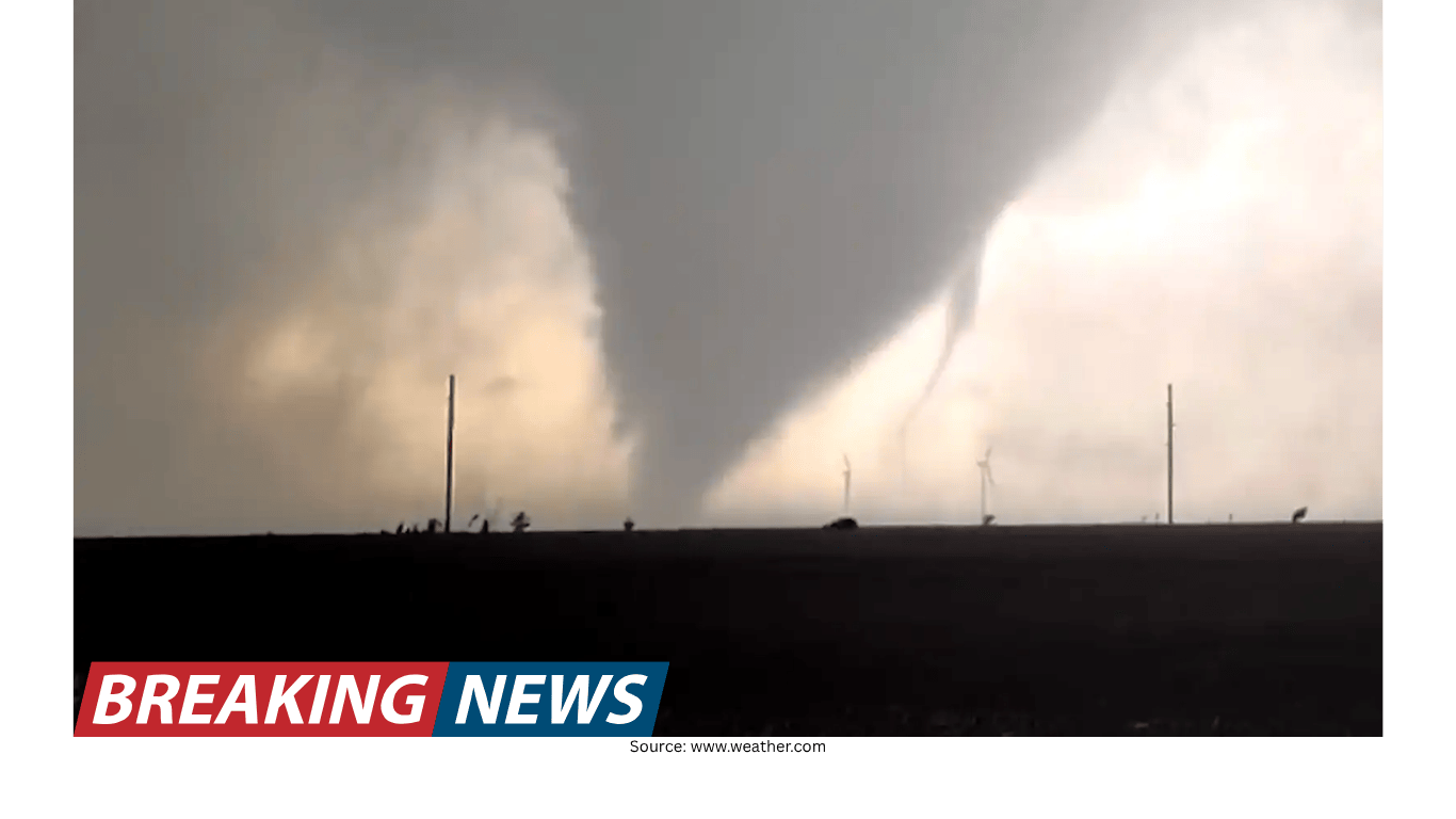
The timing is especially difficult for areas still recovering from recent tornadoes in Michigan and Oklahoma that killed six people. With the tornado risk continuing this week for parts of the Midwest and the Southwest, the latest forecast underscores how quickly severe weather concerns can return after a damaging outbreak.
Day 1: Southeast in the crosshairs
The first phase of the forecast places the Southeast at risk. On Monday, about five million people were within the area of concern for severe storms stretching from central Arkansas to central Alabama.
In that corridor, the main hazards included:
Strong wind gusts, which can down trees and power lines and cause damage even without a tornado.
Large hail, a threat that can harm vehicles, roofs, and outdoor property.
A potential tornado, which can develop quickly and may occur alongside intense thunderstorms.
Even when storms are described as “severe” in broad terms, the experience on the ground can vary widely. Some locations may see only a brief burst of wind and heavy rain, while others could face more intense conditions. The forecast range from central Arkansas to central Alabama highlights how large the area of concern can be at the start of a multi-day system.
Day 2: Focus shifts to the Midwest and southwest Texas
By Tuesday, attention turns toward the Midwest and southwest Texas. The forecast calls for two clusters of storms that could bring winds up to 60 mph and the possibility of flash flooding.
Damaging wind is often one of the most widespread impacts in severe weather events, particularly when storms organize into lines or clusters. Wind speeds near 60 mph can cause structural damage and make travel hazardous, especially for high-profile vehicles.
Flash flooding is also a key concern in this phase of the forecast. Heavy downpours can overwhelm drainage systems and quickly inundate low-lying areas. Because flash flooding can develop rapidly and may occur at night, it can be especially dangerous for drivers.
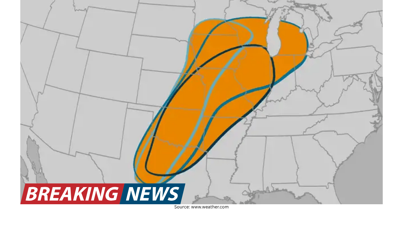
Midweek: A broad swath at risk for straight-line winds
As the middle of the week approaches, the risk expands again. Straight-line winds are expected to push from central Pennsylvania to central Louisiana, placing 27 million people at risk.
Straight-line winds can be as damaging as weaker tornadoes, particularly when they occur over a wide area. The forecast span—from central Pennsylvania down through to central Louisiana—illustrates how a single weather pattern can affect communities across multiple states and regions, even if the most intense storms are concentrated in smaller pockets.
For residents within this large zone, the forecast suggests the potential for fast-moving storms and wind-driven impacts that can include downed trees, power outages, and debris hazards. The size of the at-risk population also highlights the importance of staying aware of local watches and warnings as conditions evolve.
Oklahoma braces again after a deadly tornado
Oklahoma is preparing for more severe weather only days after devastating tornadoes killed a mother and daughter in Fairview. The deaths of Jodie Owens, 47, and her daughter Lexi Owens, 13, have become a painful reminder of how quickly tornado emergencies can turn tragic.
According to Jodie’s brother, Justin Zonts, the two were found dead in a vehicle just west of Fairview at about 10 p.m. Thursday. He said they were driving home after Jodie picked up Lexi from a friend’s house.
Zonts said the mother and daughter were racing home after receiving a tornado warning and had called to warn family members at home to take shelter. He described them as a family that tried to be prepared, noting that there was a storm shelter at the home.
“She’s telling them how they need to take cover. They’ve got a storm shelter put in their home. They just, they always try to be prepared,” Zonts said. “But, unfortunately, she was on the phone with her daughter just as the storm hit.”
He also emphasized the challenge of nighttime tornadoes, saying a tornado at night can be essentially invisible. In those conditions, he said, a driver may have no clear sense of what is ahead or how close the circulation is.
Zonts described his sister and niece as “constantly together” and joked they were attached at the hip. He said Jodie and her husband, David, who have eight children, moved to Oklahoma in recent years.
As the state braces for additional severe weather, the Fairview tragedy underscores the stakes when tornado warnings are issued—particularly after dark, when visibility is limited and decision-making time can be short.
Michigan continues to recover from last week’s outbreak
The same deadly outbreak that struck Oklahoma also hit Michigan, where three people were killed in the Union City area. The storm system also claimed the life of 12-year-old Silas Anderson in Cass County, Michigan.
Edwardsburg Public Schools’ superintendent confirmed the boy’s death in a letter to staff and families. “It is with a very heavy heart that I share the tragic passing of one of our sixth-grade students,” the letter began.
In the Union City area, the Branch County Sheriff’s Office said William Andrew Akers, 63, Keri Ann Johnson, 54, and Penni Jo Guthrie, 65, were found dead in close proximity.
These losses have left communities mourning while also confronting the practical aftermath that follows severe storms, including damage cleanup and the emotional toll of recovery. The forecast for continued tornado risk in parts of the Midwest adds another layer of concern as residents try to rebuild and regain a sense of normalcy.
Why this pattern is drawing attention
Multi-day severe weather events can be especially challenging because the risk is not confined to a single afternoon or a single state. Instead, the potential for dangerous storms can reappear as the system progresses, shifting from one region to another.
In this forecast period, the sequence is clear:
Beginning in the Southeast with severe storms and isolated flash flooding expected over the next three days.
Transitioning to the Midwest and southwest Texas where storm clusters could bring up to 60 mph winds and flash flooding.
Expanding into a large midweek wind threat from central Pennsylvania to central Louisiana, placing 27 million people at risk.
At each stage, the hazards can differ, and the same location may face more than one threat, such as wind and flooding, or hail and tornado potential. That variability is one reason forecasters emphasize staying updated as new information comes in.
Warmth returns to parts of the East after a cold winter
Alongside the severe weather concerns, parts of the East Coast are finally seeing warmer conditions after what was described as a bitterly cold winter.
New York City reached 69 degrees on Sunday. It was the city’s first 60-degree day since early November and ended New York City’s longest stretch of consecutive days below 60 degrees since the winter of 1981 to 1982.
Farther south, Tampa reached 90 degrees on Sunday, marking the city’s earliest 90-degree day on record.
These temperature milestones highlight the sharp contrasts that can occur across the country at the same time—warmth building in some areas while other regions face the threat of severe storms and flooding. While the warmer readings are separate from the immediate storm hazards described in the forecast, they reflect the broader variability in weather conditions occurring across the U.S. during this period.
Staying aware as conditions evolve
With severe storms and isolated flash flooding expected over several days, the most important takeaway for communities in the risk areas is that the forecast can evolve quickly. The threat on one day may center on hail and wind in one region, then shift to flash flooding or tornado potential elsewhere.
For areas still recovering from the deadly tornadoes in Michigan and Oklahoma, the renewed alert is a reminder that severe weather seasons can bring repeated rounds of storms. As the system progresses from the Southeast into the Midwest and beyond, residents across the affected regions may need to monitor local updates closely, especially during evening and overnight hours when storms can be harder to see and warnings can arrive with little time to spare.
Related Articles